|
||

|

|
|

|
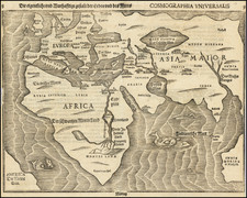
Shows the Sea of Corea
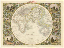
The map of the Eastern Hemisphere crafted by Covens & Mortier in 1720 is a testament to the geographical knowledge and the spirit of exploration that marked the early 18th century. Rooted in Guillaume De L'Isle's design, this edition specifically distinguishes itself by the absence of any details pertaining to the Russian Discoveries post-1730, offering a snapshot of the world before these significant expeditions.
1. Terres Australes ou Antarctiques: Translated as "Southern or Antarctic Lands", this region is named on the map, but intriguingly, no land is depicted. The name hints at the longstanding European belief in a vast, undiscovered southern continent that would balance out the known lands in the Northern Hemisphere.
2. Tasman's Route past Van Diemens Land: The Dutch explorer Abel Tasman is credited with the European discovery of Tasmania (then named Van Diemen's Land in honor of Anthony van Diemen, the Governor-General of the Dutch East Indies). The map showcases this route, revealing an incomplete representation of Australia, which aligns with the limited European exploration of the continent at the time.
3. Narrow Strait between New Guinea and Australia: A notably slender strait divides New Guinea and Australia on this map, drawing inspiration from the voyages of William Dampier, an English pirate turned explorer. Dampier's observations would have been pivotal in informing this geographical detail, though we now know the Torres Strait is more expansive.
4. Edmund Halley's Route in the South Atlantic: The renowned astronomer and mathematician, Edmund Halley, undertook maritime expeditions, particularly in the South Atlantic. His journey, driven by scientific curiosity to study magnetic variations, is marked on the map, highlighting the intertwined nature of science and exploration during this era.
5. Return Routes of Tasman and Le Maire: Beyond his initial discoveries, the return journeys of Tasman, as well as that of Jacob Le Maire, another important Dutch explorer, are delineated to the east of New Guinea. Their voyages not only expanded European knowledge but also facilitated trade and maritime connections.
6. Gaetan's Route to Mindanao: A less celebrated but significant explorer, Gaetan's journey towards Mindanao, passing through the Pescadore Islands and the Isles de Palaos, is chronicled on the map. This route underscores the extensive reach of European explorers in the Pacific.
7. The Sea of Korea (Mer de Coree): Interestingly, the map identifies the Sea of Korea, a body of water between Korea and Japan. In contemporary parlance, this is often a geopolitical point of contention, with alternate naming as the "East Sea". The Covens & Mortier's decision to depict it as the "Mer de Coree" (Sea of Korea) reflects the naming conventions of that era.
Johannes Covens (1697-1774) was a Dutch geographic publisher based in Amsterdam. He is best known for his collaboration with fellow publisher Cornelis Mortier (1699-1783). Pierre Mortier the Elder (1661-1711) had obtained a privilege in 1690 to distribute the works of French geographers in the Netherlands. After his widow continued the business for several years, Cornelis took over in 1719.
In 1721, Mortier forged a partnership with Covens, who had recently married Cornelis’ sister. They published under the joint name of Covens & Mortier. In 1774, upon the death of his father, Johannes Covens II (1722-1794) took over his father’s share. In 1778, the company changed its name to J. Covens & Zoon, or J. Covens & son.
Covens II’s son, Cornelis (1764-1825), later inherited the business and brought Petrus Mortier IV back into the fold. Petrus was the great-grandson of Petrus Mortier I. From 1794, the business was called Mortier, Covens & Zoon, or Mortier, Covens, & Son.
The business specialized in publishing French geographers including Deslisle, Jaillot, and Sanson. They also published atlases, for example a 1725 reissue of Frederik de Wit’s Atlas Major and an atlas, with additions, from the works of Guillaume Delisle. There were also Covens & Mortier pocket atlases and town atlases. The company profited from acquiring plates from other geographers as well. For example, the purchased Pieter van der Aa’s plates in 1730. Finally, they also compiled a few maps in house. At their height, they had the largest collection of geographic prints ever assembled in Amsterdam.
Pierre, or Pieter, Mortier (1661-1711) was a Dutch engraver, son of a French refugee. He was born in Leiden. In 1690 he was granted a privilege to publish French maps in Dutch lands. In 1693 he released the first and accompanying volume of the Neptune Francois. The third followed in 1700. His son, Cornelis (1699-1783), would partner with Johannes Covens I, creating one of the most important map publishing companies of the eighteenth century.
![A view of the division of the land of Canaan and the situation of the city and sanctuary [Manuscript map]](https://storage.googleapis.com/raremaps/img/small/87556.jpg)