|
||

|

|
|

|
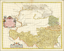
This is a detailed early map of China from 1736, created by Johann Matthaus Haas in collaboration with Homann Heirs, a respected German publishing house. The map is based on the work of Jean-Baptiste Bourguignon d'Anville, a renowned French cartographer of the 18th century.
The groundwork for this map originates from the Kangxi Atlas. Between 1708 and 1716, Qing Emperor Kangxi tasked a group of Jesuit surveyors with the job of charting his vast kingdom. The resulting Kangxi Atlas, produced from 1718-19, was the most accurate representation of China's geography for over a century.
D'Anville used the Kangxi maps as a reference for his own work, which was initially printed in Jean-Baptiste Du Halde's Description Geographique … de la Chine. The atlas by Du Halde, based on d'Anville's interpretations, was considered the foremost authority on Chinese geography during the 18th century.
Haas's map, a derivative of d'Anville's adaptation, adds its own stylistic features and accuracies to the depiction of China's landscapes. Thus, it represents a significant contribution to the 18th-century European understanding of China's geography.
Homann Heirs was a German publishing firm that enjoyed a major place in the European map market throughout the eighteenth century. Founded in 1702 by Johann Baptist Homann, the business passed to his son, Christoph, upon Johann’s death in 1724. Christoph died in 1730, aged only 27, and the firm was inherited by subsequent Homann heirs. This altered the name of the company, which was known as Homann Erben, or Homann heirs. The firm continued in business until 1848.