|
||

|

|
|

|
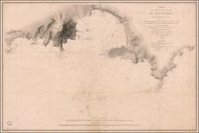
República Argentina Territorio Nacional de la Tierra del Fuego, Antártida e Islas del Atlántico Sur, issued in 1973 by the Argentine Military Geographic Institute, encapsulates a significant and contentious period of Argentine geopolitics and the history of Antarctica.
This period in the early 1970s was characterized by Argentina's vigorous assertion of its territorial rights in Antarctica, mirrored in the detailed depiction of the region on this map. This national sentiment was exemplified by an event in August 1973, a few months after the map's publication. Argentina's seat of government briefly shifted to a polar island, as President Raúl Lastiri, his Cabinet, and the wife of former President Juan IX Perón journeyed over 2,600 miles to the Vice Comodoro Marambio airbase on Seymour Island. This visit, conducted to celebrate Air Force Day, was a pointed affirmation of Argentina's claim to an Alaska-sized wedge of Antarctic territory reaching the South Pole—a claim also staked by Chile, Britain, and with emerging interest from Brazil.
The map, in its intricate detailing of glaciers, ice barriers, depth soundings in meters, and the demarcation of provincial capitals, localities, and international and Antarctic limits, offers a tangible embodiment of these geopolitical tensions. The Argentine Military Geographic Institute's meticulous charting of these territories manifests the nation's resolute ambition to delineate and uphold its perceived sovereignty in the face of international contestation.
Moreover, the map's inset, placing the Antarctic territory within the broader context of southern South America, speaks to Argentina's broader regional strategy. This cartographic representation underscores the nation's insistence on linking its Antarctic claims with its continental geography, a strategy meant to reinforce its territorial rights within international discussions.
The map shows the route of the 1965 first Argentine Expedition to the South Pole.
The map thus serves as a potent material testament to a significant chapter of Argentine history and international relations. Reflecting the intricate contours of geopolitical struggle, the map stands as a significant artifact of historical and cartographic interest.
![[ Railroad Map of Argentina ] Mapa De Los FF. CC. Argentinos Ferrocarril Sud](https://storage.googleapis.com/raremaps/img/small/101986.jpg)