|
||

|

|
|

|
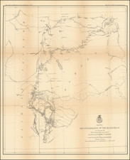
J.H. Colton's 1860 Map of Dakota and Minnesota: A Snapshot Before the Civil War
The mid-19th century was a period of significant transformation in the American Midwest. The emergence of new states, territorial boundaries, and a relentless westward push painted a picture of a nation in flux. The 1860 map of Dakota and Minnesota, created by the renowned cartographer J.H. Colton, offers a revealing snapshot of this transitional period, shortly before the tumultuous Civil War disrupted the nation's trajectory.
At a cursory glance, the division between Dakota and Minnesota is prominently marked. This separation, made official on May 11, 1858, was still relatively fresh at the time of the map's creation.
Colton's map does not include Wadena County, established just a month after the division on June 11, 1858. Conversely, the map does showcase Kandiyohi County (formed October 12, 1858) and the early traces of Becker County, which came into existence on November 2, 1860.
One of the striking features of this map is the sparse demarcation of counties, especially in the northern expanses. Northern Minnesota, a region characterized by its dense forests and lakes, has only a few counties marked. Even more sparse is Dakota, with a mere two counties indicated. This scarcity underscores the nascent stages of territorial organization and settlement in these areas.
Colton's map provides more than just political boundaries. The early proposed railroad lines, a testament to the burgeoning age of steam and steel, snake across the landscape. These rail lines, while merely proposals at the time, hint at the imminent infrastructural transformation that would forever change the Midwest's economic and demographic fabric.
Another fascinating feature is the inclusion of "Indian information." While not detailed, this inclusion speaks to the original inhabitants of these lands and the interactions (often fraught) between settlers and Native American tribes. Given the era, the map would likely reference key tribal territories, trading posts, or significant sites of interaction.
A noteworthy annotation on the map is a "note on the prairies." The vast prairies of the Midwest, characterized by their sprawling grasslands, played a pivotal role in shaping the region's ecology and early agricultural pursuits. These prairies, while essential for grazing and farming, were also emblematic of the vast, untouched wilderness that awaited settlers.
Lastly, the early township surveys in Minnesota, indicative of the meticulous process of division and organization, are displayed. These surveys reflect the systematic approach to land distribution and settlement, a precursor to the vast agricultural expanses that would come to define Minnesota in the subsequent decades.
G. W. & C. B. Colton was a prominent family firm of mapmakers who were leaders in the American map trade in the nineteenth century. Its founder, Joseph Hutchins Colton (1800-1893), was a Massachusetts native. Colton did not start in the map trade; rather, he worked in a general store from 1816 to 1829 and then as a night clerk at the United States Post Office in Hartford, Connecticut. By 1830, he was in New York City, where he set up his publishing business a year later.
The first printed item with his imprint is dated 1833, a reprint of S. Stiles & Company’s edition of David Burr’s map of the state of New York. He also printed John Disturnell’s map of New York City in 1833. Colton’s next cartographic venture was in 1835, when he acquired the rights to John Farmer’s seminal maps of Michigan and Wisconsin. Another early and important Colton work is his Topographical Map of the City and County of New York and the Adjacent Country (1836). In 1839, Colton began issuing the Western Tourist and Emigrant’s Guide, which was originally issued by J. Calvin Smith.
During this first decade, Colton did not have a resident map engraver; he relied upon copyrights purchased from other map makers, most often S. Stiles & Company, and later Stiles, Sherman & Smith. Smith was a charter member of the American Geographical and Statistical Society, as was John Disturnell. This connection would bear fruit for Colton during the early period in his career, helping him to acquire the rights to several important maps. By 1850, the Colton firm was one of the primary publishers of guidebooks and immigrant and railroad maps, known for the high-quality steel plate engravings with decorative borders and hand watercolors.
In 1846, Colton published Colton’s Map of the United States of America, British Possessions . . . his first venture into the wall map business. This work would be issued until 1884 and was the first of several successful wall maps issued by the firm, including collaborative works with D.G. Johnson. From the 1840s to 1855, the firm focused on the production of railroad maps. Later, it published a number of Civil War maps.
In 1855, Colton finally issued his first atlas, Colton’s Atlas of the World, issued in two volumes in 1855 and 1856. In 1857 the work was reduced to a single volume under the title of Colton’s General Atlas, which was published in largely the same format until 1888. It is in this work that George Woolworth (G. W.) Colton’s name appears for the first time.
Born in 1827 and lacking formal training as a mapmaker, G. W. joined his father’s business and would later help it to thrive. His brother Charles B. (C. B.) Colton would also join the firm. Beginning in 1859, the General Atlas gives credit to Johnson & Browning, a credit which disappears after 1860, when Johnson & Browning launched their own atlas venture, Johnson’s New Illustrated (Steel Plate) Family Atlas, which bears Colton’s name as the publisher in the 1860 and 1861 editions.
J.H. Colton also published a number of smaller atlases and school geographies, including his Atlas of America (1854-56), his Illustrated Cabinet Atlas (1859), Colton’s Condensed Cabinet Atlas of Descriptive Geography (1864) and Colton’s Quarto Atlas of the World (1865). From 1850 to the early 1890s, the firm also published several school atlases and pocket maps. The firm continued until the late 1890s, when it merged with a competitor and then ceased to trade under the name Colton.
![Johnson's Nebraska, Dakota, Montana and Kansas [Rare Pre-Wyoming Territory configuration]](https://storage.googleapis.com/raremaps/img/small/94909.jpg)