|
||

|

|
|

|
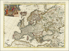
This splendid specimen of Herman Moll's cartographic artistry is a miniature map of Europe from his renowned Atlas Minor, engraved in 1729. It is a superb example of Moll's meticulous craftsmanship and unique style that have made his maps highly sought-after collectibles.
The map's composition predominantly mirrors the cartographic contours of Moll's larger map of Europe, created in the preceding decade. Yet, despite its relatively compact format, it does not compromise on detail, showing the intricate outlines of Europe's borders, water bodies, and key geographical landmarks with remarkable precision.
Europe, as depicted by Moll, is a fascinating patchwork of kingdoms, empires, and states, their boundaries meticulously etched in a fine mesh of lines. The coastline is painstakingly rendered, and the continent's major rivers are clearly indicated, providing crucial navigational information.
All in all, this 1729 miniature engraved map of Europe by Herman Moll reflects not only the topographical knowledge of its time but also the enduring skill and artistry of one of
Herman Moll (c. 1654-1732) was one of the most important London mapmakers in the first half of the eighteenth century. Moll was probably born in Bremen, Germany, around 1654. He moved to London to escape the Scanian Wars. His earliest work was as an engraver for Moses Pitt on the production of the English Atlas, a failed work which landed Pitt in debtor's prison. Moll also engraved for Sir Jonas Moore, Grenville Collins, John Adair, and the Seller & Price firm. He published his first original maps in the early 1680s and had set up his own shop by the 1690s.
Moll's work quickly helped him become a member of a group which congregated at Jonathan's Coffee House at Number 20 Exchange Alley, Cornhill, where speculators met to trade stock. Moll's circle included the scientist Robert Hooke, the archaeologist William Stuckley, the authors Jonathan Swift and Daniel Defoe, and the intellectually-gifted pirates William Dampier, Woodes Rogers and William Hacke. From these contacts, Moll gained a great deal of privileged information that was included in his maps.
Over the course of his career, he published dozens of geographies, atlases, and histories, not to mention numerous sheet maps. His most famous works are Atlas Geographus, a monthly magazine that ran from 1708 to 1717, and The World Described (1715-54). He also frequently made maps for books, including those of Dampier’s publications and Swift’s Gulliver’s Travels. Moll died in 1732. It is likely that his plates passed to another contemporary, Thomas Bowles, after this death.
![[ Through Cooperation to Communism ] Spolupraci ke Komunismu](https://storage.googleapis.com/raremaps/img/small/97646.jpg)