


|
||

|

|
|

|
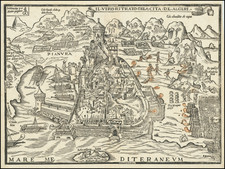
One of the earliest obtainable maps of Morocco and the Straights of Gibraltar.
This is Tabula Prima di Libya quale Aphrica, the first of four Libya (i.e. North Africa) maps issued in Francesco Berlinghieri’s ground-breaking atlas Septe Giornate della Geographia from 1482.
The map depicts the westernmost part of North Africa, constituting Morocco and most of Algeria today. The scope stretches from the Atlantic coast to the 28th parallel in the eastern desert of Algeria.
Comparing this map to other editions of Ptolemy, it is clear Berlinghieri drew on additional sources. This difference is most evident in the number and density of coastal place names, which significantly exceed its Rome and Ulm counterparts. Berlinghieri’s map also offers stylistic differences. Both Rome and Ulm depict a rugged coastline with deep bays and numerous promontories, whereas Berlinghieri carves the coast out in circles to form an elegant cloverleaf-like border.
The Iberian Peninsula extends from the top of the map to form the iconic gateway between the Atlantic and Mediterranean - the Gibraltar Strait (Freto Herculeo). Once again, Berlinghieri departs significantly from his peers, drawing a longer and more rugged course for this passage. It is worth noting the inclusion of a small pictogram of a column on the east side of the Morrocan promontory extending up towards the Strait of Gibraltar. This illustration is labeled Colona di Phebo, meaning the 'column of the illuminated,' a well-known reference to the Greco-Roman god Apollo. We have yet to confirm the exact meaning of this term - Column of Apollo - and relevant publications do not discuss it. Nevertheless, this misnomer is likely a reference to the ‘Pillars of Hercules,' as the Gibraltar Straits were known in Antiquity.
Much of the toponymy is unrecognizable today, drawing as it does on Ptolemy's original lists and suffering centuries of slow linguistic corruption through translation and transcription. A few places are nevertheless both identifiable and worth mentioning. Following the annexation of western North Africa by the Roman Emperor Claudius in 44 CE, it was divided into two Roman provinces, each with its own provincial capital. The Roman provincial capital was Volubilis in the westernmost province of Mauretania Tingitana. Volubilis was also the old capital of the Kingdom of Numidia, which Claudius had "integrated" into the Roman Empire. To this day, it remains one of the most impressive Roman ruin fields in North Africa. Volubilis can be seen almost directly south of Apollo's column, just southwest of the singular peak labeled DIOR MOT.
The eastern half of Mauretania became Mauretania Caesarensis and was ruled from the coastal hub of Jol Caesarea (modern Cherchell in Algeria). On Berlinghieri's map, this is labeled Casarea. Immediately north of the city, and partly obscured by the centerfold, is the island of Julia Caesarea. This island was named after Julius Caesar's favorite daughter, whom he married to Consul Pompey to keep the friendship pact between them alive. Once Julia died in childbirth, however, the path to civil war lay open.
Two other small islands, Pena and Erythia, are depicted on the Atlantic. It is unclear precisely what these islands represent, although they figure in all three mentioned editions of Ptolemy. The southern island most likely represents Mogador, the largest of the Essaouira Islands (or Iles Purpuraires), which have been harvesting grounds for purple dye since Antiquity.
A notable feature of the North African interior is the elaborate mountain ranges that cut across the entire map. One of the characteristic features of Berlinghieri's map is the ornamental nature of mountain ranges, delineated by bold wavy lines and hatched in the middle. The depicted ranges represent real and imagined mountains in Morocco. Thus, the Atlas and Ante-Atlas ranges are shown, but the map also includes an extensive and mythical southern range, which continues east out of the map and cuts across most of the Sahara.
States of the map
For a long time, most scholars agreed that much, if not all, of the Septe giornate was completed by 1479, including the maps, which were interpreted as having been printed in a single large batch and then subsequently bound and published in 1482 (Skelton 1966; Campbell 1987). A significant number of extra sheets were left over from the original printing. After Berlinghieri died in 1501, these were purchased and bound into a new edition with a new title page issued around 1503-1504.
Nevertheless, a new and comprehensive study by Peerlings and Laurentius (2023) has identified subtle distinctions in many of Berlingheiri’s maps, denoting that amendments were made and that different states thus exist.
For Tabula Prima di Libya quale Aphrica, Peerlings and Laurentius identify two distinct states. The current example is the second state, identified by overprinting on the first word in the label GARAPHA MONT in the lower half of the left page, close to the centerfold. In addition, the second state includes a C-shaped blotch immediately below the mountain, and just southeast of it, another place name, Macur, has also been overprinted, affecting legibility (Peerlings & Laurentius 2023: 179).
Claudius Ptolemy (fl. AD 127-145) was an ancient geographer, astronomer, and mathematician. He is known today through translations and transcriptions of his work, but little is known about his life besides his residence in Alexandria.
Several of his works are still known today, although they have passed through several alterations and languages over the centuries. The Almagest, in thirteen books, discusses astronomy. It is in the Almagest that Ptolemy postulates his geocentric universe. His geometric ideas are contained in the Analemma, and his optical ideas were presented in five books known as the Optica.
His geographic and cartographic work was immensely influential. In the Planisphaerium, Ptolemy discusses the stereographic projection. Perhaps his best-known work is his Geographia, in eight books. However, Ptolemy’s ideas had been absent from western European intellectual history for roughly a thousand years, although Arab scholars interacted with his ideas from the ninth century onward.
In 1295, a Greek monk found a copy of Geographia in Constantinople; the emperor ordered a copy made and the Greek text began to circulate in eastern Europe. In 1393, a Byzantine diplomat brought a copy of the Geographia to Italy, where it was translated into Latin in 1406 and called the Cosmographia. The manuscript maps were first recorded in 1415. These manuscripts, of which there are over eighty extant today, are the descendants of Ptolemy’s work and a now-lost atlas consisting of a world map and 26 regional maps.
When Ptolemy’s work was re-introduced to Western scholarship, it proved radically influential for the understanding and appearance of maps. Ptolemy employs the concept of a graticule, uses latitude and longitude, and orients his maps to the north—concepts we take for granted today. The Geographia’s text is concerned with three main issues with regard to geography: the size and shape of the earth; map projection, i.e. how to represent the world’s curve proportionally on a plane surface; and the corruption of spatial data as it transfers from source to source. The text also contains instructions as to how to map the world on a globe or a plane surface, complete with the only set of geographic coordinates (8000 toponyms, 6400 with coordinates) to survive from the classical world.
Francesco Berlinghieri (1440-1501) was a Florentine engraver. Nicolas Laurentii published Berlinghieri's edition of Ptolemy, which was written in Italian terza rima, comprising 123 folios of text and 31 engraved maps. The work was first printed in 1482, but most surviving examples come from the edition of 1486, which was the first edition to include red printing in the title page. The full title is Geographia. In Questo Volume Si Congengono Septe Giornate Della Geographia Di Francesco Berlingeri Fiorentino Allo Illustrissimo Federigo Duca . . .
Berlinghieri's edition of Ptolemy is unique, in that it includes 31 maps covering Europe, northern Africa and the south part of Asia and is the first atlas to attempt the introduction of modern geography, with the inclusion of four new maps - France, Italy, Spain and Palestine, which are based on contemporary knowledge. rather than a strict plotting of Ptolemy's coordinates. A number of other maps in the Berlinghieri edition of Ptolemy include data which is drawn from modern sources, albeit more subtlely so, in part because of transcription errors and in part because of corrections made over time by later scholars.
While Berlinghieri's atlas was the third Italian printed edition of Ptolemy, it was very important in other respects. Berlinghieri's Ptolemaic regional maps are drawn on Marinus' plane projection; and although not generally considered an edition of Ptolemy, the maps are the only examples of Ptolemy's maps to be drawn on the original projection, with equidistant meridians and parallels. Berlinghieri's work was also the first to include a printed Gazetteer for each of the maps.
The text by Berlingheiri is a metrical paraphrase of Ptolemy, the first atlas in the Italian language. Francesco Berlinghieri was an Italian scholar and humanisrt. He promoted the value of classical Greek learning and therefore was the first to print an edition of Ptolemy in vernacular Italian, rather than Latin. The maps look distorted as compared to modern maps, because Ptolemy's data was inaccurate. One reason is that Ptolemy estimated the size of the Earth as too small: while Eratosthenes of Cyrene, a Greek mathematician, elegiac poet, athlete, geographer, and astronomer, made several discoveries and inventions including a system of latitude and longitude and conceived the idea of 700 stadia for a degree on the globe, in the Geographia Ptolemy uses 500 stadia. It is not certain if these geographers used the same stadion, but if we assume that they both stuck to the traditional Attic stadion of about 185 meters, then the older estimate is 1/6 too large, and Ptolemy's value is 1/6 too small. Because Ptolemy derived most of his topographic coordinates by converting measured distances to angles, his maps get distorted. So his values for the latitude were in error by up to 2 degrees. For longitude this was even worse, because there was no reliable method to determine geographic longitude.
Ptolemy was well aware of this. It must be added that his original topographic list cannot be reconstructed: the long tables with numbers were transmitted to posterity through copies containing many scribal errors, and people have always been adding or improving the topographic data: this is a testimony to the persistent popularity of this influential work in the history of cartography..
As early as 1938 Arthur M. Hind, Keeper of Prints and Drawings at the British Museum, hinted that the engravings might have been made by Francesco Rosselli (1448-before 1527), the principal engraver in Florence in the 1480s and 1490s. Subsequently, this possibility was rejected by Roberto Almagiagrave, R. A. Skelton and Tony Campbell. In the author's view, however, both stylistic and circumstantial evidence argues that Francesco was indeed the engraver, and that this first major commission launched the career that eventually made him known to his contemporaries as 'Franciscus rosellus florentinus Cosmographus'.
![[With Early Annotations!] Nuova et Copiosa Descrittione Di Tutto L'Egitto Pur hora de Paulo Forlani Veronese intagliata in Venetia lanno 1566](https://storage.googleapis.com/raremaps/img/small/75556.jpg)
![[ Algerian Viticulture ] Carte Viti-Vinicole de l'Algerie](https://storage.googleapis.com/raremaps/img/small/97857.jpg)
![The West Part of Barbary... [on sheet with:] The East Part of Barbary...](https://storage.googleapis.com/raremaps/img/small/94055.jpg)