


|
||

|

|
|

|
This is Francesco Berlinghieri’s Tabula Quinta de Asia, one of the rarest and most desirable early maps of Persia and Mesopotamia, where some of history’s first great civilizations arose, including some of the earliest agriculture, urbanism, and writing. It comes from Berlinghieri’s ground-breaking Ptolemaic atlas, Septe Giornate della Geographia, an innovative and exceptional volume first published in 1482.
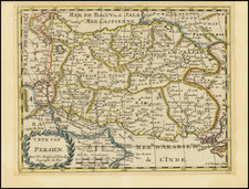
In modern terms, most of the area shown on the map corresponds to the contemporary nation-states of Iraq and Iran (with parts of Kuwait, Azerbaijan, and Armenia also showing). This region has a richly varied topography, in which spheres of political and cultural influence are defined by natural boundaries formed by mountain ranges, rivers, or the sea.
The most notable feature on the map is the Zagros Mountains (Choathra Mote). Just as this massive range separates the modern nation-states of Iraq and Iran, it once separated the ancient Mesopotamian cultures from their Persian counterparts. In Berlinghieri’s map, the Zagros Mountains are shown linking up with the Taurus Mountains of southern Anatolia (Niphate Mote), in effect walling off Mesopotamia to the left side of the map.
Mesopotamia
The other notable feature on the map is its many sizable rivers. ‘Mesopotamia’ means ‘between the two rivers,’ referring to the floodplain between the great Euphrates (Eufrate Fl.) and Tigris (Tigri Fl.). The designation is not indigenous to the region but a later Greek name given to this area by geographers such as Strabo and Ptolemy. It was along this valley that some of the first civilizations developed.
Berlinghieri depicts the rivers of Mesopotamia with thick dark lines flowing south from the Taurus Mountains and into the Persian Gulf. Their actual course is somewhat different than what is represented here, but there is a degree of logic to the zig-zagging flows. Ever since the first civilizations developed here, manipulating river flow has been crucial for irrigation. This technology allowed agriculture to be harnessed to control food production. Generating surplus in food production was the essential pre-requisite that allowed humankind to develop all its other decisive attributes – from social hierarchies to empires.
Within Mesopotamia, we note the regional toponyms of Assyria in the north and Babylonia in the south. Among the significant centers noted in this region, we find most along the banks of the rivers. We see the great western capital of the Persian Sassanid dynasty at Ctesiphon on the Tigris River, and slightly further downstream – at the confluence of the Euphrates and Tigris – is the ancient capital of Babylon (marked but not labeled), which in the 9th century CE was transformed by the Abbasids to become the Iraqi capital of Baghdad. Even though Baghdad lies on the banks of the Tigris, it is correct that its location is where the two river flows are closest to each other.
Ancient Iran
Moving east across the Zagros Mountains, Susa is one of the first famous place names to note. This was the capital of the Elamites, the greatest enemy to Mesopotamian kingdoms for millennia. Persian geography was generally not well-known to Europeans in Antiquity or during the Renaissance when this map was produced. A few key sources defined the region for both Ptolemy and Berlinghieri. While Ptolemy drew on ancient texts such as Xenophon’s Anabasis and the accounts of Alexander the Great, Berlinghieri also consulted the travels of Marco Polo.
The map’s geography of Persia is an excellent window into how this ancient region was understood in late 15th-century Europe. Territories are labeled according to ancient Persian dynasties, such as Media and Parthia. The Elbrus Mountains near the Caspian Sea have been moved inland, pushing the Central Iranian Plateau (Parthia) to the east. At the eastern edge of the map, Persia is delineated by another mountain range marked Masdorano Mo., which essentially denotes the Khorasan and Sistan Mountains and thus border with Afghanistan and Central Asia.
Berlinghieri’s map also includes two unusual illustrated place names:
- The Gates of the Zagros (Porta di Zagro), a label found in the easternmost reaches of the Zagros Mountains and enhanced with a simplistic vignette of a double gate. This represents the most critical pass across the mountains, known and fought over since the Bronze Age. It is one of the significant passes across the Zagros (i.e. the Tang-e Meyran).
- Slightly to the northwest of the gates and in the region labeled Media is a small depiction of a flower. Below it, we find the name Martiana Palube. Despite our best efforts, we have yet to determine the nature of this place name or the meaning of its rendition. It is one of many toponyms from 15th-century Ptolemaic atlases we can no longer identify.
Berlinghieri: A Unique Tradition of Cartography
The cartography of Francesco di Niccolo Berlinghieri is viewed as a distinct tradition within the framework of Ptolemaic mapmaking. Most scholars agree that Berlinghieri used sources different from his contemporaries to delineate the world’s land masses. The configuration of the Mediterranean, in particular, appears to have drawn on alternative sources. A common explanation is that Berlinghieri, as a Florentine, had access to far older and more accurate portolan charts and possibly even sources from within the Islamic world. Unfortunately, confirming what those alternative sources might have been remains speculative.
An important distinction between his Ptolemaic atlas and other 15th-century versions was Berlinghieri’s deliberate use of the archaic homeotheric or equidistant cylindrical projection, which is attributed to Ptolemy’s predecessor and primary source of geographic information: Marinus of Tyre (c.100 CE). As far as we know, Ptolemy never actually made maps himself, so we do not know which projection he favored.
Nevertheless, by the time the first Ptolemaic Geographies were going into print, most mapmakers had shifted to the new trapezoidal projection attributed to German cartographer Donnus Nicolaus (c.1420-1490).
Cartographic scholar Peter Meurer points out that all known Ptolemaic Geographies from the 15th century were built directly on the manuscripts of Donnus Nicolaus but that Nicolaus himself used different projections over time. While the new trapezoidal projection, known as the “Donis-projection,” was used in the Rome Ptolemy and the influential maps of Henricus Martellus, the Ulm edition returned to an equidistant cylindrical projection to present the new and updated understanding of Scandinavia based on the work of Danish cartographer Claudius Clavus.
Berlinghieri’s Septe Giornate is the only 15th-century atlas to use multiple projections depending on what parts of the world were presented. The creative process behind the Septe Giornate thus differed from that of contemporary Geographies.
States of the map
For a long time, most scholars agreed that much, if not all, of the Septe giornate was completed by 1479, including the maps, which were interpreted as having been printed in a single large batch and then subsequently bound and published in 1482 (Skelton 1966; Campbell 1987). A significant number of extra sheets were left over from the original printing. After Berlinghieri died in 1501, these were purchased and bound into a new edition with a new title page issued around 1503-1504.
A new and comprehensive study by Peerlings and Laurentius (2023) has nevertheless managed to identify subtle distinctions in many of Berlingheiri’s maps, denoting that there were amendments made and that different states thus exist.
For Tabula Quinta de Asia, Peerlings and Laurentius identify two distinct states (2023: 184-185), which can be distinguished by over-printing one letter in a single regional toponym. Located on the left side of the map, near the centerfold and just above the central meridian, we find the regional toponym: SAGARTII or SAGAREII. SAGARTII indicates the first state, and SAGAREII (with the ‘E’ overprinted) marks the second state. The current example is the second state.
Census
There are several listings of Berlinghieri’s Septe Giornate in the OCLC, including at the Universities of Oxford, Manchester, and Yale, as well as with the New York Public Library, the LIBRIS library in Stockholm, and the Morgan Library and Museum in New York (no. 644313849). For the Tabula Quinta de Asia, the OCLC has only two listings, one at the Bayerische Staatsbibliothek in Munich (no. 164796934) and one at Middlebury College in Vermont (no. 227145483).
Minor wear at the fold expertly retouched.
Campbell, Tony (1987). The Earliest Printed Maps (1472-1500), British Library: London.
Gibson, D. (2013). Suggested Solutions for Issues Concerning the Location of Mecca in Ptolemy’s Geography.
Nabatea Hamad bin Seray (1997). The Arabian Gulf in Syriac Sources. In: New Arabian Studies, Vol. 4. G.R. Smith & B.R. Pridham (eds.). Exeter: Exeter University Press. Pp. 205-232.
Helas, Philine. (2002). The "Flying Map". Le 'Septe Giornate della Geographia,' by Francesco Berlinghieri \ dedicated to Federico da Montefeltro and Lorenzo de Medici, and depictions of the world in 15th-century Florence (Cartography). Mitteilungen des Kunsthistorischen Institutes in Florenz 46: 271-320.
Peerlings, R.H.J. & F. Laurentius (2023). Berlinghieri’s Geography Unveiled. Freely available at www.berlinghieri.eu Skelton, R.A. (1966). A bibliographical note prefixed to the facsimile of Berlinghieri’s Geographia, Theatrum Orbis Terrarum: Amsterdam.
Meurer, Peter H. (2007). 42 - Cartography in the German Lands, 1450–1650. In The History of Cartography, Volume 3, Part 2. David Woodward (ed.). Chicago: University of Chicago Press. pp. 1182–1183.
Claudius Ptolemy (fl. AD 127-145) was an ancient geographer, astronomer, and mathematician. He is known today through translations and transcriptions of his work, but little is known about his life besides his residence in Alexandria.
Several of his works are still known today, although they have passed through several alterations and languages over the centuries. The Almagest, in thirteen books, discusses astronomy. It is in the Almagest that Ptolemy postulates his geocentric universe. His geometric ideas are contained in the Analemma, and his optical ideas were presented in five books known as the Optica.
His geographic and cartographic work was immensely influential. In the Planisphaerium, Ptolemy discusses the stereographic projection. Perhaps his best-known work is his Geographia, in eight books. However, Ptolemy’s ideas had been absent from western European intellectual history for roughly a thousand years, although Arab scholars interacted with his ideas from the ninth century onward.
In 1295, a Greek monk found a copy of Geographia in Constantinople; the emperor ordered a copy made and the Greek text began to circulate in eastern Europe. In 1393, a Byzantine diplomat brought a copy of the Geographia to Italy, where it was translated into Latin in 1406 and called the Cosmographia. The manuscript maps were first recorded in 1415. These manuscripts, of which there are over eighty extant today, are the descendants of Ptolemy’s work and a now-lost atlas consisting of a world map and 26 regional maps.
When Ptolemy’s work was re-introduced to Western scholarship, it proved radically influential for the understanding and appearance of maps. Ptolemy employs the concept of a graticule, uses latitude and longitude, and orients his maps to the north—concepts we take for granted today. The Geographia’s text is concerned with three main issues with regard to geography: the size and shape of the earth; map projection, i.e. how to represent the world’s curve proportionally on a plane surface; and the corruption of spatial data as it transfers from source to source. The text also contains instructions as to how to map the world on a globe or a plane surface, complete with the only set of geographic coordinates (8000 toponyms, 6400 with coordinates) to survive from the classical world.
Francesco Berlinghieri (1440-1501) was a Florentine engraver. Nicolas Laurentii published Berlinghieri's edition of Ptolemy, which was written in Italian terza rima, comprising 123 folios of text and 31 engraved maps. The work was first printed in 1482, but most surviving examples come from the edition of 1486, which was the first edition to include red printing in the title page. The full title is Geographia. In Questo Volume Si Congengono Septe Giornate Della Geographia Di Francesco Berlingeri Fiorentino Allo Illustrissimo Federigo Duca . . .
Berlinghieri's edition of Ptolemy is unique, in that it includes 31 maps covering Europe, northern Africa and the south part of Asia and is the first atlas to attempt the introduction of modern geography, with the inclusion of four new maps - France, Italy, Spain and Palestine, which are based on contemporary knowledge. rather than a strict plotting of Ptolemy's coordinates. A number of other maps in the Berlinghieri edition of Ptolemy include data which is drawn from modern sources, albeit more subtlely so, in part because of transcription errors and in part because of corrections made over time by later scholars.
While Berlinghieri's atlas was the third Italian printed edition of Ptolemy, it was very important in other respects. Berlinghieri's Ptolemaic regional maps are drawn on Marinus' plane projection; and although not generally considered an edition of Ptolemy, the maps are the only examples of Ptolemy's maps to be drawn on the original projection, with equidistant meridians and parallels. Berlinghieri's work was also the first to include a printed Gazetteer for each of the maps.
The text by Berlingheiri is a metrical paraphrase of Ptolemy, the first atlas in the Italian language. Francesco Berlinghieri was an Italian scholar and humanisrt. He promoted the value of classical Greek learning and therefore was the first to print an edition of Ptolemy in vernacular Italian, rather than Latin. The maps look distorted as compared to modern maps, because Ptolemy's data was inaccurate. One reason is that Ptolemy estimated the size of the Earth as too small: while Eratosthenes of Cyrene, a Greek mathematician, elegiac poet, athlete, geographer, and astronomer, made several discoveries and inventions including a system of latitude and longitude and conceived the idea of 700 stadia for a degree on the globe, in the Geographia Ptolemy uses 500 stadia. It is not certain if these geographers used the same stadion, but if we assume that they both stuck to the traditional Attic stadion of about 185 meters, then the older estimate is 1/6 too large, and Ptolemy's value is 1/6 too small. Because Ptolemy derived most of his topographic coordinates by converting measured distances to angles, his maps get distorted. So his values for the latitude were in error by up to 2 degrees. For longitude this was even worse, because there was no reliable method to determine geographic longitude.
Ptolemy was well aware of this. It must be added that his original topographic list cannot be reconstructed: the long tables with numbers were transmitted to posterity through copies containing many scribal errors, and people have always been adding or improving the topographic data: this is a testimony to the persistent popularity of this influential work in the history of cartography..
As early as 1938 Arthur M. Hind, Keeper of Prints and Drawings at the British Museum, hinted that the engravings might have been made by Francesco Rosselli (1448-before 1527), the principal engraver in Florence in the 1480s and 1490s. Subsequently, this possibility was rejected by Roberto Almagiagrave, R. A. Skelton and Tony Campbell. In the author's view, however, both stylistic and circumstantial evidence argues that Francesco was indeed the engraver, and that this first major commission launched the career that eventually made him known to his contemporaries as 'Franciscus rosellus florentinus Cosmographus'.
![[ Persia ]](https://storage.googleapis.com/raremaps/img/small/74992.jpg)
![[ Khorosan / Iran ] Versuch einer Darstellung von Khorassan zu C. Ritter's Erdkunde Drittes Buch Iranische Welt](https://storage.googleapis.com/raremaps/img/small/68105.jpg)