


|
||

|

|
|

|
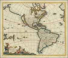
Antique Map of America -- California as an Island - Old Color
Old color example of Frederick De Wit's fine early map of the Americas and Pacific.
Includes California as an Island, an early depiction of the Great Lakes (not present in Visscher's edition of the map), non-existent coastline north of the Island of California and misprojected South America. This first state of the map predates the information in the NW and Oceana. The map predates La Salle's information on the interior of North America, but includes excellent detail in Canada and the East Coast of North America, noting the Dutch possessions, the Iroquois regions, N. Anglia, New Amsterdam, the Chesapeake, Plymouth, and many Indian place names.
Burden identifies 9 states of the map:
- State 1: 1675 ca: Longitudinal numbers given in 10s. Madera named. Includes sailing ship.
- State 2: 1678 ca: Canaries re-engraved, with "Madera Ins" named.
- State 3: 1678 ca: Longitudinal lines are now shown by 8s.
- State 4: 1680 ca: 3 ships in Pacific and 8 ships in Atlantic are removed
- State 5: 1680 ca: Nova Guinea and Quiri Regio appear in South Pacific and Terrea Esonis to the west of California
- State 6: 1688 ca: Aovenliouach ronons appears between Lac Superior and Lac des Puans
- State 7: 1690 ca: New title: " Novissima et Accuratissima Septentrionalis ac Meridionalis Americae Descriptio .... " At 338° longitude at the bottom of map the plate now includes a significant plate crack and an erased compass rose, with 4 sections missing
- State 8: 1695 ca: Plate crack repaired and four missing sections noted above repaired area
- State 9: 1710 ca: Includes the Mortier imprint
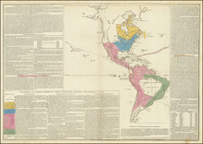
The popular misconception of California as an island can be found on European maps from the sixteenth through the eighteenth centuries. From its first portrayal on a printed map by Diego Gutiérrez, in 1562, California was shown as part of North America by mapmakers, including Gerardus Mercator and Abraham Ortelius. In the 1620s, however, it began to appear as an island in several sources. While most of these show the equivalent of the modern state of California separated from the continent, others, like a manuscript chart by Joao Teixeira Albernaz I (ca. 1632) now in the collection of the National Library of Brasil shows the entire western half of North Americas as an island.
The myth of California as an island was most likely the result of the travel account of Sebastian Vizcaino, who had been sent north up the shore of California in 1602. A Carmelite friar, Fray Antonio de la Ascensión, accompanied him. Ascension described the land as an island and around 1620 sketched maps to that effect. Normally, this information would have been reviewed and locked in the Spanish repository, the Casa de la Contratación. However, the manuscript maps were intercepted in the Atlantic by the Dutch, who took them to Amsterdam where they began to circulate. Ascensión also published descriptions of the insular geography in Juan Torquemada’s Monarquia Indiana (1613) (with the island details curtailed somewhat) and in his own Relación breve of ca. 1620.
The first known maps to show California as an island were on the title pages of Antonio de Herrera’s Descripción de las Indias Occidentales (1622) and Jacob le Maire's Spieghel Der Australische Navigatie (1622). Two early examples of larger maps are those by Abraham Goos (1624) and another by Henry Briggs, which was included in Samuel Purchas’ Hakluytus Posthumus or Purchas his Pilgrimes (1625). In addition to Briggs and Goos, prominent practitioners like Jan Jansson and Nicolas Sanson adopted the new island and the practice became commonplace. John Speed’s map (1626-7), based on Briggs’ work, is well known for being one of the first to depict an insular California.
The island of California became a fixture on mid- and late-seventeenth century maps. The island suggested possible links to the Northwest Passage, with rivers in the North American interior supposedly connecting to the sea between California and the mainland. Furthermore, Francis Drake had landed in northern California on his circumnavigation (1577-80) and an insular California suggested that Spanish power in the area could be questioned.
Not everyone was convinced, however. Father Eusebio Kino, after extensive travels in what is now California, Arizona, and northern Mexico concluded that the island was actually a peninsula and published a map refuting the claim (Paris, 1705). Another skeptic was Guillaume De L’Isle. In 1700, De L’Isle discussed “whether California is an Island or a part of the continent” with J. D. Cassini; the letter was published in 1715. After reviewing all the literature available to him in Paris, De L’Isle concluded that the evidence supporting an insular California was not trustworthy. He also cited more recent explorations by the Jesuits (including Kino) that disproved the island theory. Later, in his map of 1722 (Carte d’Amerique dressee pour l’usage du Roy), De L’Isle would abandon the island theory entirely.
Despite Kino’s and De L’Isle’s work, California as an island remained common on maps until the mid-eighteenth century. De L’Isle’s son-in-law, Philippe Buache, for example, remained an adherent of the island depiction for some time. Another believer was Herman Moll, who reported that California was unequivocally an island, for he had had sailors in his offices that claimed to have circumnavigated it. In the face of such skepticism, the King of Spain, Ferdinand VII, had to issue a decree in 1747 proclaiming California to be a peninsula connected to North America; the geographic chimera, no matter how appealing, was not to be suffered any longer, although a few final maps were printed with the lingering island.
De Wit (1629 ca.-1706) was a mapmaker and mapseller who was born in Gouda but who worked and died in Amsterdam. He moved to the city in 1648, where he opened a printing operation under the name of The Three Crabs; later, he changed the name of his shop to The White Chart. From the 1660s onward, he published atlases with a variety of maps; he is best known for these atlases and his Dutch town maps. After Frederik’s death in 1706, his wife Maria ran the shop for four years before selling it. Their son, Franciscus, was a stockfish merchant and had no interest in the map shop. At the auction to liquidate the de Wit stock, most of the plates went to Pieter Mortier, whose firm eventually became Covens & Mortier, one of the biggest cartography houses of the eighteenth century.
![A New Mapp of America Septentrionale . . . 1669 [California shown as an island]](https://storage.googleapis.com/raremaps/img/small/94304.jpg)
![A New Map of North America Shewing its Principal Divisions, Chief Cities, Townes, Rivers, Mountains &c. Dedicated to His Highness William Duke of Gloucester [California as an Island]](https://storage.googleapis.com/raremaps/img/small/100578.jpg)