|
||

|

|
|

|
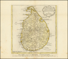
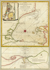
This two-map sheet, published in London on 12th May 1794 by Laurie & Whittle, offers detailed charting of the Bay of Trincomenale (or Trincomalee) alongside a plan of Venlos Bay on the East Coast of Ceylon (present-day Sri Lanka).
During the latter part of the 18th century, Ceylon was a focal point for colonial powers due to its strategic location. Trincomalee, with its notable natural harbor, was a sought-after location for naval and trade activities, drawing attention from European colonizers such as the Dutch, Portuguese, and British. This map, with its precise geographical details and maritime markers, reflects the navigational necessities of the time.
The map also presents internal geographical features, including hills, marshlands, and lakes. The diverse set of place names, a blend of native Sinhalese, Tamil, and colonial terms, gives a glimpse into the cultural interactions and colonial influences of the period.
Overall, The Bay of Trincomenale and Plan of Venlos Bay capture key locations on the East Coast of 18th-century Ceylon, providing a view into its maritime significance and the interplay of local and colonial elements during a period marked by colonial interests.
Both maps are taken from original work produced by the Van Keulen firm.
Robert Laurie (ca. 1755-1836) and James Whittle (1757-1818) formed their Fleet Street, London-based firm upon the 1794 death of their employer Robert Sayer, himself one of the dominant print and mapmakers of the last half of the 18th century.
Laurie & Whittle started managing Sayer's business as early as 1787. They took over all managerial duties when Sayer's health flagged in 1792, and they changed the imprint in 1794 upon his death. Sayer left the two a 21-year lease on the shop (at £100 a year) and on Sayer's Bolt Court premises, as well as an option to acquire stock and equipment at a preferential price of £5,000 payable over three years.
Robert Laurie retired from the firm in 1812, and his role was assumed by his son, Richard Holmes Laurie (1777-1858). The younger Laurie worked with James Whittle until the latter died in 1818. After R. H. Laurie died in 1858, Alexander George Findlay, FRGS (1812-1875) purchased the firm from his daughters. The firm continues today under another name, specializing in yachting charts.
Laurie & Whittle were prolific print and map publishers, and throughout their careers, they produced numerous very important and rare works. They carried on Robert Sayer's atlas business and were responsible for editions of The Complete East-India Pilot and The American Atlas.

![(Jaffna, Sri Lanka) Ein Prospect Castells Jaffnapatnam, wie sich daslelbe uber das Wasser gegen das Thor, der Compagnie Stall, u werff praessentiret [A view of the castle of Jaffna, as it appears from the water towards the gate, the Company stable, and the rampart.]](https://storage.googleapis.com/raremaps/img/small/0109gh.jpg)
![[Sri Lanka] Ceylon](https://storage.googleapis.com/raremaps/img/small/74202.jpg)