|
||

|

|
|

|
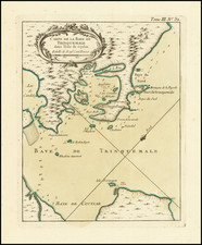
Calpentyn Road, on the West Coast of Ceylon and The East Coast of Ceylon, from Venlos Bay to Batecalo, published by Laurie & Whittle in 1794, provide an in-depth cartographic survey of the coasts of Ceylon, now known as Sri Lanka. Derived from maps by the renowned Dutch cartographic family Van Keulen, these maps present essential maritime details such as soundings, banks, and rocks that would have been of crucial importance for navigation and trade during the period.
The transition from Dutch to British rule in Ceylon in the late 18th century marked a significant shift in the island's colonial history. The Dutch, having controlled significant parts of the maritime regions of Ceylon since the mid-17th century, primarily through the Dutch East India Company, faced increasing pressure from the British in the region. By 1795, amidst the backdrop of the Napoleonic Wars and the resulting geopolitical realignments, the British East India Company managed to seize control of Dutch-held territories in Ceylon. The Dutch formally ceded sovereignty over the island to the British in the 1796 Treaty of Amiens. This transition initiated the onset of British dominance in Ceylon, leading to its eventual transformation into a crown colony in 1802 and marking the beginning of a new chapter in the island's colonial narrative.
Robert Laurie (ca. 1755-1836) and James Whittle (1757-1818) formed their Fleet Street, London-based firm upon the 1794 death of their employer Robert Sayer, himself one of the dominant print and mapmakers of the last half of the 18th century.
Laurie & Whittle started managing Sayer's business as early as 1787. They took over all managerial duties when Sayer's health flagged in 1792, and they changed the imprint in 1794 upon his death. Sayer left the two a 21-year lease on the shop (at £100 a year) and on Sayer's Bolt Court premises, as well as an option to acquire stock and equipment at a preferential price of £5,000 payable over three years.
Robert Laurie retired from the firm in 1812, and his role was assumed by his son, Richard Holmes Laurie (1777-1858). The younger Laurie worked with James Whittle until the latter died in 1818. After R. H. Laurie died in 1858, Alexander George Findlay, FRGS (1812-1875) purchased the firm from his daughters. The firm continues today under another name, specializing in yachting charts.
Laurie & Whittle were prolific print and map publishers, and throughout their careers, they produced numerous very important and rare works. They carried on Robert Sayer's atlas business and were responsible for editions of The Complete East-India Pilot and The American Atlas.
![[Sri Lanka -- with Elephant] Sumatra ein grosse Insel / So Von Den Alten Geographen Taprobana / Ist Genent Worden](https://storage.googleapis.com/raremaps/img/small/91096.jpg)