|
||

|

|
|

|
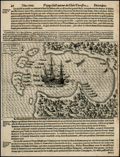
Detailed chart of the passage between Bankga Island and the mainland of Sumatra.
The chart is a navigational aid illustrating the maritime area surrounding Bangka Island, situated off the eastern coast of Sumatra, an island historically recognized for its tin production. It features extensive depth measurements stemming from the surveys conducted by the 'General Elliot', designated as a "Country Ship". This nomenclature was used by British officials in India to categorize local ships engaged in intra-Asian trade, in contrast to those on the Asia-Europe routes. Thus, British vessels not affiliated with the East India Company and operating in these regions were termed English country traders.
The “Advertisement” on the map warns that “the Whole Coast of this part of Sumatra, is very low, and has no perceivable height, but that of the Trees with which it is covered. The Sea washes the foot of those Trees, and very often rises to their top, which then induces you to reckon yourself farther from the Coast than you are in reality”.
The chart likely is related to an earlier chart done by Captain Lestock Wilson. Wilson and his crew drew sketch charts of the area. One of these charts was available in a voyage account published by mate George Roberston in 1788. William Bligh, of Mutiny on the Bounty fame, wrote the following in his Voyage to the South Sea, regarding the sinking of Wilson’s ship, Vansittart, on October 9, 1789 near Bangka:
This day anchored in the road the General Elliot, an English ship commanded by Captain Lloyd. In the Straits of Banca he had met with some boats belonging to the East India Company's ship Vansittart that was lost in the straits of Billaton by having struck on a rock that went through her bottom. Captain Wilson, who commanded the Vansittart, I was informed had just finished a survey of those Straits and was hoisting his boat in when the ship struck. Immediately on receiving the intelligence Captain Lloyd, in the General Elliot and another ship in company called the Nonsuch, sailed for the wreck. They found the ship had been burnt down to the water's edge by the Malays. They however saved 40 chests of treasure out of 55 which were said to have been on board. Most of the ship's company were saved: one man only was lost in the ship, and five others in a small boat were missing who were supposed to have taken some of the treasure.
Rarity
The chart appeared in an Laurie & Whittle’s rare 'East India Pilot'.
Robert Laurie (ca. 1755-1836) and James Whittle (1757-1818) formed their Fleet Street, London-based firm upon the 1794 death of their employer Robert Sayer, himself one of the dominant print and mapmakers of the last half of the 18th century.
Laurie & Whittle started managing Sayer's business as early as 1787. They took over all managerial duties when Sayer's health flagged in 1792, and they changed the imprint in 1794 upon his death. Sayer left the two a 21-year lease on the shop (at £100 a year) and on Sayer's Bolt Court premises, as well as an option to acquire stock and equipment at a preferential price of £5,000 payable over three years.
Robert Laurie retired from the firm in 1812, and his role was assumed by his son, Richard Holmes Laurie (1777-1858). The younger Laurie worked with James Whittle until the latter died in 1818. After R. H. Laurie died in 1858, Alexander George Findlay, FRGS (1812-1875) purchased the firm from his daughters. The firm continues today under another name, specializing in yachting charts.
Laurie & Whittle were prolific print and map publishers, and throughout their careers, they produced numerous very important and rare works. They carried on Robert Sayer's atlas business and were responsible for editions of The Complete East-India Pilot and The American Atlas.

![[Sangihe Island and Talaud Islands, Indonesia] Het Eyland Sangir (and) De Talutse Eylanden](https://storage.googleapis.com/raremaps/img/small/74784.jpg)