|
||

|

|
|

|
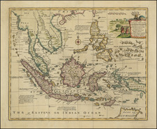
This 1798 engraving by Laurie & Whittle, entitled A Plan of the Isles of Merguy on the Coast of Tanasserim and Plan of Junkseylon Island and Its Harbour on the Coast of Queda, showcases the fine detail and careful artistry characteristic of late-18th-century maritime cartography. The work, derived from the records of M. d'Après de Mannevillette and M. Forten, master of H.M.'s Ship Heroine, provides valuable navigational information about two significant locations in what are present-day Thailand and nearby regions.
The first chart depicts the archipelago of Mergui, located off the coast of the Tanintharyi Region of modern-day Myanmar. Known for its untouched islands, it is considered an exotic vacation spot today, attracting those seeking tranquility and natural beauty.
The second chart features a detailed layout of Phuket, formerly known as Junkseylon. Situated off the West Coast of Queda (now Kedah, Malaysia), Phuket is one of Thailand's premier tourist destinations, renowned for its golden beaches, rich cultural history, and vibrant nightlife.
These detailed navigational maps not only encapsulate the geographic features of these areas but also include additional observations. For example, the note on the second chart provides practical maritime advice for anchoring, availability of resources like wood and water, and prevailing conditions on the shore. These observations, while primarily targeted at seafarers in the 18th century, inadvertently provide a window into the past for these now-popular tourist locales.
Overall, these maps exemplify the meticulous craft of maritime cartography in the late 18th century and concurrently offer a historical perspective of the locations that are today sought-after tourist destinations.
Robert Laurie (ca. 1755-1836) and James Whittle (1757-1818) formed their Fleet Street, London-based firm upon the 1794 death of their employer Robert Sayer, himself one of the dominant print and mapmakers of the last half of the 18th century.
Laurie & Whittle started managing Sayer's business as early as 1787. They took over all managerial duties when Sayer's health flagged in 1792, and they changed the imprint in 1794 upon his death. Sayer left the two a 21-year lease on the shop (at £100 a year) and on Sayer's Bolt Court premises, as well as an option to acquire stock and equipment at a preferential price of £5,000 payable over three years.
Robert Laurie retired from the firm in 1812, and his role was assumed by his son, Richard Holmes Laurie (1777-1858). The younger Laurie worked with James Whittle until the latter died in 1818. After R. H. Laurie died in 1858, Alexander George Findlay, FRGS (1812-1875) purchased the firm from his daughters. The firm continues today under another name, specializing in yachting charts.
Laurie & Whittle were prolific print and map publishers, and throughout their careers, they produced numerous very important and rare works. They carried on Robert Sayer's atlas business and were responsible for editions of The Complete East-India Pilot and The American Atlas.
![S.E. Peninsula and Malaysia [Singapore inset and Pulo Penang or Price of Wales Island inset]](https://storage.googleapis.com/raremaps/img/small/103012.jpg)
![[Elephants & Tourism] Chaine Des Elephants Plateau Du Bo'kor [Southeastern Cambodia]](https://storage.googleapis.com/raremaps/img/small/64472.jpg)