|
||

|

|
|

|
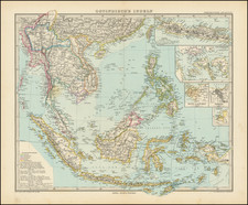
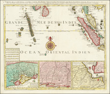
One of the Best 18th-Century English Charts of the Straits of Singapore.
This map, titled "The Straits of Sincapore with those of Drion, Sabon, Mandol &ca and South Part of Malacca Straits Improved and Corrected from the Observations of Captn. John Hall of the Worcester, Captn. J. Lindsey, Captn. Elmore, and other Navigators", was published in London by Laurie & Whittle on January 1, 1799.
For the time, the map provided an accurate representation of the Singapore and Malacca Straits, relying on the first-hand observations of notable sea captains such as John Hall, J. Lindsey, and Elmore, who had navigated the area. This area was, and still is, a significant global shipping route connecting the Pacific and Indian Oceans, making accurate maps critical for safe navigation.
The map details the geography of the region extending from Sumatra in the southwest to just north of Singapore in the north. Various islands, including Batam ("Pulo Battam"), Bintan ("Pulo Bintang"), and Lingga ("Isle Linging or Lingan"), are depicted.
The accompanying text is an extract from Captain Elmore's journal from the ship Gratitude, providing a detailed account of a journey through the Straits of Malacca in December 1784. It offers rich details such as wind direction, landmarks, distances, depths, and the location of dangers such as rocks and shoals.
The map follows a very similar chart produced by Sayer & Bennett in 1778, demonstrating the continued relevance of these sea routes and the evolving understanding of their geography over time.
Robert Laurie (ca. 1755-1836) and James Whittle (1757-1818) formed their Fleet Street, London-based firm upon the 1794 death of their employer Robert Sayer, himself one of the dominant print and mapmakers of the last half of the 18th century.
Laurie & Whittle started managing Sayer's business as early as 1787. They took over all managerial duties when Sayer's health flagged in 1792, and they changed the imprint in 1794 upon his death. Sayer left the two a 21-year lease on the shop (at £100 a year) and on Sayer's Bolt Court premises, as well as an option to acquire stock and equipment at a preferential price of £5,000 payable over three years.
Robert Laurie retired from the firm in 1812, and his role was assumed by his son, Richard Holmes Laurie (1777-1858). The younger Laurie worked with James Whittle until the latter died in 1818. After R. H. Laurie died in 1858, Alexander George Findlay, FRGS (1812-1875) purchased the firm from his daughters. The firm continues today under another name, specializing in yachting charts.
Laurie & Whittle were prolific print and map publishers, and throughout their careers, they produced numerous very important and rare works. They carried on Robert Sayer's atlas business and were responsible for editions of The Complete East-India Pilot and The American Atlas.
![Asiatic Archipelago [Early Singapore Inset]](https://storage.googleapis.com/raremaps/img/small/66879.jpg)