|
||

|

|
|

|
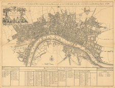
Large, Separately-Issued Plan of the Public Sewer System in the City of London. Predating John Snow's Pioneering Work on Water Safety in 1854.
A General Plan of the Public Sewers within the City of London and the Liberties Thereof, created by Richard Kelsey and completed by William Haywood in 1847, is an exceptional testament to the City of London's efforts to combat sanitation-related issues, most notably cholera, which posed significant health risks during the 19th century.
Cholera epidemics were a severe problem during this time, often linked to the poor quality of London's water and sanitation systems. The map, marking the junction of the county and city sewers in blue, outlines the comprehensive sewer system of the City of London, offering an in-depth insight into the extensive network engineered to manage waste and improve public health. William Santler, the inspector, oversaw the project ensuring the accuracy of the document.
In the 1840s, understanding the role of sanitation in disease prevention was not as advanced as it is today. The prevalent belief, the miasma theory, argued that diseases like cholera were caused by 'bad air'. However, in the mid-1850s, Dr. John Snow debunked this theory by demonstrating the link between cholera and contaminated water sources, which revolutionized public health and disease prevention efforts.
Thus, this map represents more than a simple illustration of the sewer system; it symbolizes an era of pioneering sanitation improvements that marked the beginning of the fight against cholera and other diseases related to poor hygiene conditions. By visualizing the city's sewer network, the map sheds light on the monumental challenges faced by engineers and health professionals in their attempts to protect London's inhabitants and create a healthier, safer urban environment.
Rare.
![[View of London, etc.] Abilltung wie königliche Maistät in Engelandt Die Artickel Dess Spanischen Heyraths Jur: Bekreftiget Anno 1623](https://storage.googleapis.com/raremaps/img/small/90777.jpg)
![[London / Tower of London ] La tour de Londres](https://storage.googleapis.com/raremaps/img/small/101674.jpg)