|
||

|

|
|

|
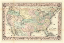
Nice example of the first state of SA Mitchell Jr.'s map of the United States.
The map provides an interesting snapshot of the Trans-Mississippi West's shifting borders. New Mexico is shown north of Arizona along what later became known as the Baylor Line, which is related to the Gadsden Purchase of 1854 when the U.S. acquired regions of present-day southern Arizona and southwestern New Mexico from Mexico.
Nebraska is depicted extending from the Rocky Mountains to Iowa, and the expansive Dacotah Territory includes all of what is now Montana and Wyoming, along with a part of Idaho. The Washington Territory is shown enveloping Oregon and most of what is currently Idaho. Nevada's depiction is smaller, with Las Vegas included in New Mexico and its eastern border with Utah placed several degrees west of its final location due to concerns about the growing Mormon community in Utah.
The map also features the newly established Colorado Territory, just a year into its existence. It showcases a range of topographical and historical information such as early explorers' routes, forts, Indigenous communities, railroads, towns, rivers, and mountains.
Samuel Augustus Mitchell Jr. inherited the Mitchell Company from his father in 1860. For over thirty years, the company had specialized in the production of school atlases and wall maps of America. They were one of the pioneers on engraving on steel plates. In 1860, Samuel Jr. released the New General Atlas, which had been compiled in house and replaced a previous atlas by Tanner. The elder Mitchell died in 1868 and Samuel Jr. continued the business until the 1890s. At its height, the Mitchell Company employed 250 people and sold 400,000 publications annually.
![[ First Map to Name The United States ] L'Amerique septentrionale ou se remarquent les Etats Unis . . . 1779](https://storage.googleapis.com/raremaps/img/small/94192.jpg)
![[ Military Departments ] Johnson's New Military Map of the United States Forts, Military Posts & all the Military Divisions with Enlarged Plans of the Southern Harbors . . .](https://storage.googleapis.com/raremaps/img/small/101114.jpg)