


|
||

|

|
|

|
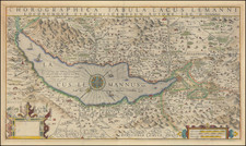
Suisse or Switzerland with their Allies and Subjects & c. Agreable to Modern History, by Herman Moll, is a distinctive map dating from 1729 that offers a compelling historical and geographical portrayal of Switzerland and its surrounding territories. Published in London, this map delineates the country's 12 cantons, further detailing their religious affiliations, and breaks down the territorial dimensions of Switzerland in an exceptionally precise manner. Furthermore, it stands out as a remarkable example of Herman Moll's cartographic work, colored meticulously by regions.
Herman Moll, a leading geographer and cartographer of the 18th century in England, was renowned for his precise maps and atlases. This map illustrates Moll's characteristic attention to detail, evident in its meticulous labeling, careful division of territories, and descriptive annotations. Notably, the map incorporates historical and demographic information, such as religious affiliations—categorizing cantons as Papists, Protestants, or an intermixture of both—reflecting Moll's interest in providing comprehensive geographical insights.
Housed within the wider scope of Enlightenment-era cartography, this map mirrors the era's aspirations for knowledge and precision. The Enlightenment represented a period of burgeoning scientific discovery and intellectual advancement, where maps were not only geographical tools but also represented the expanding intellectual curiosity of the era. In this context, Moll's map becomes more than a geographical representation—it serves as a manifestation of the evolving scientific thought of the period.
"Suisse or Switzerland with their Allies and Subjects & c. Agreable to Modern History" exemplifies the combination of scientific rigor, geographical knowledge, and cultural understanding in the world of 18th-century cartography. Its intricate detailing and historical data make it an invaluable document, reflecting a fascinating era in the history of map-making and human understanding of the world. As such, it stands as a significant artifact of a time when exploration, science, and cartography converged to define the contours of the modern world.
Herman Moll (c. 1654-1732) was one of the most important London mapmakers in the first half of the eighteenth century. Moll was probably born in Bremen, Germany, around 1654. He moved to London to escape the Scanian Wars. His earliest work was as an engraver for Moses Pitt on the production of the English Atlas, a failed work which landed Pitt in debtor's prison. Moll also engraved for Sir Jonas Moore, Grenville Collins, John Adair, and the Seller & Price firm. He published his first original maps in the early 1680s and had set up his own shop by the 1690s.
Moll's work quickly helped him become a member of a group which congregated at Jonathan's Coffee House at Number 20 Exchange Alley, Cornhill, where speculators met to trade stock. Moll's circle included the scientist Robert Hooke, the archaeologist William Stuckley, the authors Jonathan Swift and Daniel Defoe, and the intellectually-gifted pirates William Dampier, Woodes Rogers and William Hacke. From these contacts, Moll gained a great deal of privileged information that was included in his maps.
Over the course of his career, he published dozens of geographies, atlases, and histories, not to mention numerous sheet maps. His most famous works are Atlas Geographus, a monthly magazine that ran from 1708 to 1717, and The World Described (1715-54). He also frequently made maps for books, including those of Dampier’s publications and Swift’s Gulliver’s Travels. Moll died in 1732. It is likely that his plates passed to another contemporary, Thomas Bowles, after this death.
![[ Switzerland ] Nova Totius Helvetiae cum Suis Subditis Ac Sociis . . .](https://storage.googleapis.com/raremaps/img/small/68867.jpg)
![[ Switzerland ] Nouvelle Carte de la Suisse dans laquelle sont Exactement Distingues les Treize Cantons ... Londre Chez W. Faden Charing Cross 1799](https://storage.googleapis.com/raremaps/img/small/102958.jpg)
![(Switzerland) Tabu. Nova Helvetiae [New Map of Switzerland]](https://storage.googleapis.com/raremaps/img/small/102934.jpg)