|
||

|

|
|

|
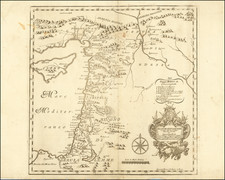
The 1750 map titled "La Judee ou Terre Sainte divisee en ses Douze Tribus," published in Paris, offers a comprehensive look at the Holy Land, or Judea, and its historical divisions based on the 12 Tribes of Israel. With its clear demarcations and detailed depiction, this map is a notable example of 18th-century cartography focused on biblical regions.
At the map's core is its division of the Holy Land into regions controlled by the 12 Tribes of Israel. The territories are distinctly outlined, allowing for a straightforward understanding of their geographical relation to one another. This layout provides valuable context for those studying biblical history or seeking an understanding of the ancient territorial divisions of the region.
An inset on the upper left side of the map depicts the journey of the Children of Abraham as they sought Canaan, the Promised Land. This feature offers a summarized route of this significant journey, providing context to one of the important narratives of the Old Testament.
The map's cartouche is both informative and decorative. Centered on it are the two tablets representing the law given to Moses. Accompanying the tablets are various symbols related to the Old Testament, adding an element of visual interest and providing additional context to the region's religious significance.
Gilles Robert de Vaugondy (1688-1766) and Didier Robert de Vaugondy (1723-1786) were influential figures in the realm of 18th-century French cartography. Originating from Paris, their contributions to mapmaking were significant during an era of expansive geographical exploration.
Gilles Robert de Vaugondy entered the world of cartography not through family tradition but through personal interest and the budding opportunities of his time. Born in 1688, he worked during a time when Paris was becoming a central hub for cartographic activities. Gilles often incorporated the latest findings from explorers into his maps, making them sought-after for their contemporary relevance. His connections weren't limited to his immediate circle; he frequently interacted with other key mapmakers, staying updated on the latest techniques and findings.
His son, Didier, was born in 1723 and had the advantage of growing up surrounded by maps and globes. While his father was renowned for maps, Didier made a name for himself in the field of globemaking. His globes were some of the most precise and detailed in France, gaining recognition even among the royalty. In addition to his work in cartography and globemaking, Didier had a keen interest in education, especially after the expulsion of the Jesuits from France. He stepped in to produce geographical educational materials, fulfilling a newfound need.
The maps and globes produced by the Vaugondys remain an enduring testament to the peak of French cartography during the Enlightenment. Their works, characterized by precision and the inclusion of contemporary findings, helped to shape our understanding of the world during a transformative period in European history.
![[Heightened with Gold Leaf! -- Paul's Travels ] De Reysen Christi Des Heyland en Pauli met andere syne Bloedgetuygen](https://storage.googleapis.com/raremaps/img/small/72900.jpg)
![[Title page -- Book of Martyrs] Acts and Monuments of Matters Most speciall and memorable, happening in the Church, with an universall Historie of same . . . 1632](https://storage.googleapis.com/raremaps/img/small/79484.jpg)
![A New Map Shewing all the several Counties, Cities, Towns, and other Places mentioned in the New Testament . . . [shows Cyprus]](https://storage.googleapis.com/raremaps/img/small/90593.jpg)