|
||

|

|
|

|
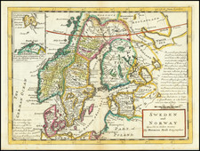
Detailed map of Sweden and Norway by Herman Moll, one of the leading English mapsellers of the early 18th Century.
Created by the accomplished cartographer Herman Moll, the map provides a fascinating insight into the geography and trade patterns of the early 18th century.
The main focus of the map is the geographical portrayal of Sweden and Norway. The physical features, such as mountains, rivers, and coasts are shown.
One intriguing feature of the map is an inset in the left right corner, dedicated to the southern part of Greenland. This relatively small but detailed segment exhibits Moll's commitment to providing a comprehensive representation of the geographical context. It also subtly highlights the importance of Greenland in the broader Northern European maritime domain.
Another notable aspect of the map is the identification of significant coastal roads. The map outlines a coastal route stretching from Hamburg and Straslund, meandering through Denmark, and reaching up the Baltic Coast of Sweden. Additionally, it illustrates a second road running from Littaw in Courland to St. Petersburg, primarily tracing the coastline. These roads, likely post routes, underline the trade routes and travel norms of the time, adding a layer of socio-economic context to the geographical depiction.
Herman Moll (c. 1654-1732) was one of the most important London mapmakers in the first half of the eighteenth century. Moll was probably born in Bremen, Germany, around 1654. He moved to London to escape the Scanian Wars. His earliest work was as an engraver for Moses Pitt on the production of the English Atlas, a failed work which landed Pitt in debtor's prison. Moll also engraved for Sir Jonas Moore, Grenville Collins, John Adair, and the Seller & Price firm. He published his first original maps in the early 1680s and had set up his own shop by the 1690s.
Moll's work quickly helped him become a member of a group which congregated at Jonathan's Coffee House at Number 20 Exchange Alley, Cornhill, where speculators met to trade stock. Moll's circle included the scientist Robert Hooke, the archaeologist William Stuckley, the authors Jonathan Swift and Daniel Defoe, and the intellectually-gifted pirates William Dampier, Woodes Rogers and William Hacke. From these contacts, Moll gained a great deal of privileged information that was included in his maps.
Over the course of his career, he published dozens of geographies, atlases, and histories, not to mention numerous sheet maps. His most famous works are Atlas Geographus, a monthly magazine that ran from 1708 to 1717, and The World Described (1715-54). He also frequently made maps for books, including those of Dampier’s publications and Swift’s Gulliver’s Travels. Moll died in 1732. It is likely that his plates passed to another contemporary, Thomas Bowles, after this death.
![[Estonia / Latvia] La Livonie Avec les frontieres de Courlande et de Finlande](https://storage.googleapis.com/raremaps/img/small/88602.jpg)