|
||

|

|
|

|
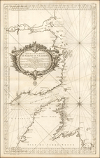
Champlain's Two-Sheet Map of New France--A Cartographic and Ethnographic Tour de Force
A testament to both cartographic innovation and artful composition, Carte Geograpique de la Nouvelle Franse by Samuel de Champlain ranks among the most remarkable cartographic accomplishments of the 17th century. This comprehensive map captures the geographical landscape of the North American coasts and its interior reaching the Great Lakes with a precision and richness of detail unmatched for its time. The map goes beyond pure cartography to integrate natural historical and ethnographic imagery, resulting in a multi-dimensional portrayal of America as it was understood at the beginning of the 17th century.
The Carte Geograpique de la Nouvelle Franse stands out in the annals of cartographic history due to its groundbreaking representations. It was the first map to propose a connected chain of the Great Lakes and to spotlight Lake Champlain and Montreal – a full 42 years before the area would see continuous habitation. A notable cartographic innovation seen in the map is the recording of individual magnetic variations, underscoring Champlain's meticulous approach and his ambition to chart new territory in map-making.
The map's unique orientation, with the top pointing towards magnetic north, represents an interesting departure from convention and is a clear nod to Cornelis Claesz's c.1594 map of the North Atlantic. In a translation of the map's caption, found in its upper left corner, Champlain explains that this peculiar orientation was chosen to aid those navigating these coasts according to compasses calibrated for the Asian hemisphere. This demonstrates Champlain's deep understanding of navigation and his readiness to adapt cartographic norms to better serve practical needs.
Champlain's method in constructing the map is also noteworthy. He chose to depend heavily on his own observations and the testimonies he received from local indigenous populations. When incorporating European sources, he displayed remarkable discernment, using only the most recent and authoritative mappings available to him. This combined approach, which championed first-hand experience and respected indigenous knowledge, lent a robustness and accuracy to Champlain's map.
A distinct feature of the Carte Geograpique de la Nouvelle Franse is its ethnographic content. The prominent placement of portraits of Montagnais and "Almouchicois" men and women signals Champlain's respect for the indigenous populations and their rich cultural traditions. This imagery reveals that in 1603, Champlain gathered significant geographical information from three different Montagnais and Algonquin sources. He was a pioneer in integrating indigenous geographical knowledge, including sketch maps, into his own cartographic efforts, a practice that would be followed by French and other European explorers in subsequent years.
The publication journey of the map is another interesting aspect of its history. Engraved in Paris in the autumn of 1612, the map encapsulates Champlain's explorations since 1603 and introduces new geographical information based on his own expeditions. His encounters with the Aboriginal people informed the depictions of previously unknown places such as Lake Ontario and Niagara Falls. While the map was engraved in 1612, it was officially published as an appendix to his Voyages in 1613.
In addition to geographical and ethnographic details, the Carte Geograpique de la Nouvelle Franse presents a rich tableau of the natural environment. It features various native vegetation, marine life, and wildlife, further enhancing its value as a historical artifact. The map, in its detailed and vibrant imagery, offers more than just geographical insight; it provides a window into the diverse ecosystems of early 17th century North America.

![(Colonial New England Ironworks) [Early 19th-century manuscript copy of 1674 New England land transaction involving John Gifford; mention of early ironworks in Massachusetts]](https://storage.googleapis.com/raremaps/img/small/93113.jpg)