|
||

|

|
|

|
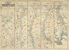
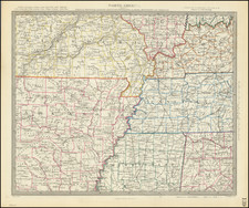
The First Railroad West of the Mississippi River -- Surveying The Initial Prospective Routes of the Pacific Railroad of Missouri
Fascinating St. Louis published map, illustrating the "Experimental Lines" of the Pacific Railroad of Missouri, the first railroad line constructed west of the Mississippi River, printed shortly after the completion of the St. Louis Railroad Convention of 1849.
This is an early map ushered in the dawn of the construction of a transcontinental railroad, which would be realized in 1852 with the opening of a 5 mile rail line proceeding west from St. Louis, the first railroad west of the Mississippi River.
The map illustrates the lines of surveys and proposed surveys for a railroad line in two general directions, one from St. Louis to "Kansas" (Kansas City) and the second southwest, in the general direction of Fayetteville, Arkansas, and what was then Indian Territory. The second line was completely unsurveyed. The line to Kansas City included one completely surveyed line and several unsurveyed lines, which were possible alternate routes. The map also meticulously tracks distances along the main surveyed line, as well as the location of mineral resources (lead, coal, copper, salt, iron, and tin). Published in St. Louis by the firm of Julius Hutawa, the map was almost certainly prepared in conjunction with fundraising efforts for the newly created Pacific Railroad of Missouri, Missouri's first real railroad and a prospective leg in a future Transcontinental railroad from St. Louis to the Pacific Ocean.
The map includes "[sic] hights of the ground above higherwater at St. Louis," with notes concerning the locations of lead, coal, salt, copper, iron and tin. Lines surveyed and proposed by unsurveyed are noted with solid or dashed lines. West of the terminus of the proposed railroad line near Independence, the Santa Fe Road is shown.
The map was produced in the wake of the St. Louis General Railroad Convention of 1849, convened to examine the prospects of a railroad connection from St. Louis to the Pacific. With the growing importance of the China trade following the opening of Chinese ports in 1843, the United States's acquisition of Upper California and the west following the Treaty of Guadalupe Hidalgo in 1848, and the California Gold Rush, it became clear to business interests in the East (both northern and southern interests) that a link to the Pacific Ocean by rail was essential for commercial success and the growth of trade. Three primary ideas flourished. A northern route, as proposed by Asa Whitney; a southern route from Memphis to San Diego or Monterey (which came to be known as the Maury Plan, named for Matthew Fontaine Maury); and a central plan, from St. Louis to San Francisco, championed by Senator Thomas Hart Benton and informed by his son-in-law, John C. Fremont. Ultimately, Stephen A. Douglas would also propose a route from Council Bluffs.
St. Louis became a contender for being the terminal for the route in February of 1849, when Benton introduced into Congress a bill for a railroad from St. Louis to San Francisco, with branches to the mouth of the Columbia. The cost would be paid with the sale of public lands in the West.
Prior to the convention, there were no railroad lines in Missouri. The first railroad convention in Missouri had been held in 1836, with 17 railroads chartered thereafter, but none had been successfully built. The first railroad built in the state was a five-mile length of track laid from Richmond to the Missouri River sometime between 1849 and 1851. The line was entirely made of wood (including the rails), and horses pulled these trains. Following the St. Louis convention of 1849, efforts to construct lines through Missouri began in earnest. The first mover of consequence was the Pacific Railroad of Missouri, chartered March 12, 1849, which initiated the construction of a line west from St. Louis in 1851, with a ground breaking ceremony on June 4, 1851, and the first passenger train on December 9, 1852. The initial line ran five miles between St. Louis and Cheltenham, making it the first railroad to operate west of the Mississippi River. Sedalia, 188 miles west of St. Louis, was reached in early 1861, and the line opened through to Kansas City in 1865.
Rarity
OCLC locates one example (British Library). The map is also in the collection of the St. Louis Mercantile Library.