


|
||

|

|
|

|
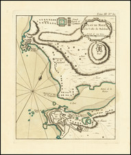
An Eye Sketch of Coringa Bay is a meticulous maritime chart of a vital location along the coast of Golconda. Conceived and executed by Captain Charles Lesley from the British man-of-war, the Orford, in July 1774, the chart provides a detailed depiction of the bay's topography and depth profile, noting various soundings taken from the ship's central position.
The chart is specific and informative about the bay's conditions. It details the steepness of the shoals, the nature of the seabed (primarily soft mud, with the exception of the sandbank), and the tidal conditions. It also notes that the waters in the bay and roadstead are calm, even though it is not uncommon to see vessels run aground due to the soft mud substrate.
The chart was published by Laurie & Whittle, a renowned London-based publishing house, on September 10, 1798. Its intention is clear: to guide mariners safely through the bay, providing them with all the necessary information to navigate its waters effectively and take advantage of its conditions for ship maintenance and repair.
On the right edge, an inset plan drawn from an actual survey conducted in 1789 by Michael Topping, a surveyor for the East India Company's Madras establishment, provides a further detailed view of Coringa Bay. This inset underscores the accuracy of the information provided and the careful, empirical approach employed in the creation of this chart.
An accompanying note from Captain Lesley in the upper right corner gives readers his personal account of the bay's strategic utility. He highlights the bay's capacity to service large ships and its role as a hub for local craftsmen who are skilled in ship repair.
He also emphasizes the availability of resources such as timber, wood, water, and fresh provisions, making the bay an ideal place for refitting ships. The local 'Doneys' (decked country boats) are mentioned as a significant resource for a squadron that might need to refit at Coringa.
Furthermore, Captain Lesley points out the bay's strategic proximity to other key locations, such as Pegu River and the Port of el Rio in the Straits of Malacca, both abundant in naval resources. He concludes by stating that Coringa Bay could, with some investment, serve as an important servicing and repair station for a fleet of warships.
However, he warns of a single shoal in the bay that could pose a threat to large ships, suggesting that a buoy could mitigate this danger.
Overall, An Eye Sketch of Coringa Bay is an excellent blend of technical maritime knowledge, strategic assessment, and practical information, providing a valuable resource for navigating and utilizing Coringa Bay during the late 18th century.
Robert Laurie (ca. 1755-1836) and James Whittle (1757-1818) formed their Fleet Street, London-based firm upon the 1794 death of their employer Robert Sayer, himself one of the dominant print and mapmakers of the last half of the 18th century.
Laurie & Whittle started managing Sayer's business as early as 1787. They took over all managerial duties when Sayer's health flagged in 1792, and they changed the imprint in 1794 upon his death. Sayer left the two a 21-year lease on the shop (at £100 a year) and on Sayer's Bolt Court premises, as well as an option to acquire stock and equipment at a preferential price of £5,000 payable over three years.
Robert Laurie retired from the firm in 1812, and his role was assumed by his son, Richard Holmes Laurie (1777-1858). The younger Laurie worked with James Whittle until the latter died in 1818. After R. H. Laurie died in 1858, Alexander George Findlay, FRGS (1812-1875) purchased the firm from his daughters. The firm continues today under another name, specializing in yachting charts.
Laurie & Whittle were prolific print and map publishers, and throughout their careers, they produced numerous very important and rare works. They carried on Robert Sayer's atlas business and were responsible for editions of The Complete East-India Pilot and The American Atlas.
![[Dutch Forts -- Jakarta, Amboine, Ternate, Solor, Banda] Vue et Description de Quelques-Uns des Principaux Forts des Hollandois dans les Indes](https://storage.googleapis.com/raremaps/img/small/43122.jpg)
![[ Hispar Glacier & Environs - World's Longest Glacial System Outside The Polar Regions ] The Karakoram Himalayas Sheet I Bagrot, Hunza, Nagyr & The Hispar Glacier Surveyed in 1892 By W. Martin Conway, & Reduced From His Drawings.](https://storage.googleapis.com/raremaps/img/small/102943.jpg)