|
||

|

|
|

|
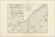
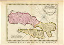
This detailed chart, titled A New Chart of the Straits of Sunda, is derived from the manuscript records of the Dutch East India Company and the practical observations of Capt. Henry Smedley in 1785, Capt. Parker of the Bridgewater in 1787, and Capt. John Hall of the Worcester in 1788. It was produced and published in London by Laurie & Whittle in May 1794.
The map primarily focuses on the Straits of Sunda, capturing the adjacent coastal regions of Sumatra and Java. Notable geographic features, including Lampoong's Bay on Sumatra and Krakatoa (before its 1883 eruption), are precisely marked. The chart also delineates part of the nearby Java Sea.
Several smaller islands are depicted between the larger landmasses of Sumatra and Java. Prince's Island, also known as Pulo Pannaitan, is proximate to the Java coastline. An inset on the map provides a more detailed view of the Zutphen or Hounds Islands, located off the eastern side of Hog's Point, the southeastern most point of Sumatra.
The map incorporates topographical features, indicating the variation in the terrain of the islands. Key trading spots and towns are marked, such as a notable mention of a landing place on Crokatoe Island frequented by Dutch ships. The map employs a clear scale and references degrees of longitude from London, essential for accurate navigation.
Krakatoa
The map shows the Krakatoa archipelago almost 100 years before it was radically altered by a colossal volcanic eruption. The Krakatoa eruption of 1883 is one of the most cataclysmic natural disasters in recorded history. Located in the Sunda Strait between the islands of Java and Sumatra in Indonesia, the once-isolated volcanic island of Krakatoa erupted with a force so immense that it resulted in the deaths of over 36,000 people. The eruption's energy was equivalent to that of thousands of atomic bombs, causing tsunamis that reached as far as the African coast and significantly affecting global climate for years. Its aftermath was no less dramatic, with the ejection of so much ash and gas into the atmosphere leading to vivid red sunsets around the world and a significant drop in global temperatures. The loudness of the explosion was so great that it was heard nearly 3,000 miles away, making it the loudest sound in recorded history.
Robert Laurie (ca. 1755-1836) and James Whittle (1757-1818) formed their Fleet Street, London-based firm upon the 1794 death of their employer Robert Sayer, himself one of the dominant print and mapmakers of the last half of the 18th century.
Laurie & Whittle started managing Sayer's business as early as 1787. They took over all managerial duties when Sayer's health flagged in 1792, and they changed the imprint in 1794 upon his death. Sayer left the two a 21-year lease on the shop (at £100 a year) and on Sayer's Bolt Court premises, as well as an option to acquire stock and equipment at a preferential price of £5,000 payable over three years.
Robert Laurie retired from the firm in 1812, and his role was assumed by his son, Richard Holmes Laurie (1777-1858). The younger Laurie worked with James Whittle until the latter died in 1818. After R. H. Laurie died in 1858, Alexander George Findlay, FRGS (1812-1875) purchased the firm from his daughters. The firm continues today under another name, specializing in yachting charts.
Laurie & Whittle were prolific print and map publishers, and throughout their careers, they produced numerous very important and rare works. They carried on Robert Sayer's atlas business and were responsible for editions of The Complete East-India Pilot and The American Atlas.