|
||

|

|
|

|
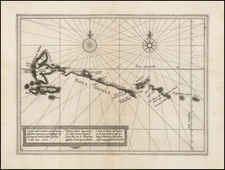
Preapred From Observations By Captain Henry Smedley in 1784
Rare navigational chart of the northern coastline of Java, including the Dutch East India Company (VOC) headquarters in Batavia, Laurie & Whittle's East-India Pilot, or Oriental Navigator . . .
Prepared from the work of Captain Henry Smedley in 1784, the chart highlights the strategic importance of this region during the high stakes contestation between England and the Netherlands, with particular focus on the storied locales of Bantam and Batavia.
The late 18th century was a critical period in the geopolitical dynamics of the Southeast Asian maritime realm. The northwestern Java coast became a center of imperial competing interests, as the region held the promise of lucrative spice trades, predominantly pepper. The British East India Company, in its ambition to rival the Dutch supremacy, established an entrepot in Bantam. However, by the time this chart was conceptualized, Bantam had faded in significance. In stark contrast, Batavia burgeoned into a sprawling metropolis, boasting a populace nearing a million, emerging as prime nexis of Java under the aegis of the Dutch East India Company (VOC), in the waning years of its existence.
Laurie and Whittle's chart is a comprehensive navigational guide. Its lineage traces back to the meticulous manuscript maps of the VOC, later refined and enhanced by an English draft from Captain Henry Smedley.
The chart is the result of observations and improvements made to prior Dutch charts by Captain Smedley, the commander of the East India Company ship Raymond. Smedley made several trips to China and India the 1780s and 1790s aboard the Raymond, but stopped in Batavia only in July 1784, where he improved several Dutch charts of the region, including this chart and Gerard Van Keulen's Plan of the Road and City of Batavia on the North Coast of Java Island from the same period. He also contributed improvements that were utilized by Laurie & Whittle for the charting of the Sunda Straits.
Rarity
As this chart only appears in the later editiions of Laurie & Whittle's East-India Pilot, or Oriental Navigator . . . , it is scarce on the market.
This is the first example we have offered.
Robert Laurie (ca. 1755-1836) and James Whittle (1757-1818) formed their Fleet Street, London-based firm upon the 1794 death of their employer Robert Sayer, himself one of the dominant print and mapmakers of the last half of the 18th century.
Laurie & Whittle started managing Sayer's business as early as 1787. They took over all managerial duties when Sayer's health flagged in 1792, and they changed the imprint in 1794 upon his death. Sayer left the two a 21-year lease on the shop (at £100 a year) and on Sayer's Bolt Court premises, as well as an option to acquire stock and equipment at a preferential price of £5,000 payable over three years.
Robert Laurie retired from the firm in 1812, and his role was assumed by his son, Richard Holmes Laurie (1777-1858). The younger Laurie worked with James Whittle until the latter died in 1818. After R. H. Laurie died in 1858, Alexander George Findlay, FRGS (1812-1875) purchased the firm from his daughters. The firm continues today under another name, specializing in yachting charts.
Laurie & Whittle were prolific print and map publishers, and throughout their careers, they produced numerous very important and rare works. They carried on Robert Sayer's atlas business and were responsible for editions of The Complete East-India Pilot and The American Atlas.
![[Buru Island, Makulu]](https://storage.googleapis.com/raremaps/img/small/74787.jpg)