|
||

|

|
|

|
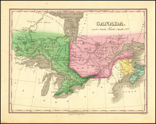
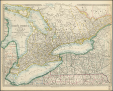
A rare lithographed Canadian map, the 1846 Smith's Commercial and Travelling Map of Canada West showcases the commercial and geographical details of what now constitutes significant portions of eastern Ontario, as well as Lakes Ontario, Erie, and Huron.
Born out of a commercial initiative to enhance traveler awareness, this map was expressly compiled for Smith's Canadian Gazetteer, which functioned as a critical source of geographic and demographic information during the mid-19th century. The presence of broad land divisions, marked by Roman numerals, encapsulates the socio-economic categorization of the region at that period. Toronto, a city of significance even then, is intriguingly denoted merely by a '1,' with its boundaries defined, yet its name absent.
At the western end of Lake Ontario, notes such as "16 M.C.," "12 M.C.," "40 M.C.," "30 M.C.," and "20 M.C." add to the enigmatic appeal of this object. Historically, such markings often denoted distances or other territorial information, providing useful insights for travelers, merchants, and other commercial entities. The peculiar system of notation prompts further inquiry, suggesting the map's value as a primary resource for research into historical cartographic techniques and their correlation with contemporary socio-economic contexts.
![[Nova Scotia Railway -- Shubenacadie Canal] (Hand Drawn Survey Maps)](https://storage.googleapis.com/raremaps/img/small/92802.jpg)