


|
||

|

|
|

|
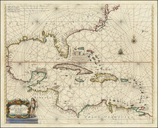
The First Sea Chart From the Carolinas to Florida
First state of Arent Roggeveen's rare sea chart of the Southeastern Coast of North America, the first sea chart to focus on the region and one of great importance, showing the region through which the majority of Spain's treasure ships from the New World sailed.
The map is based in large part of Dutch East India Company sources. The chart draws heavily on Hessel Gerritsz's rare sea chart of 1631, which survives in 3 known examples. The map is also likely based on manuscript chart by Vingboons. The place names and most of the cartographic details derives from Spanish sources.
The map appeared in Arent Roggeveen's so-called 'Burning Fen,' described by Koeman as "the most interesting of all the maritime works produced by Pieter Goos". Roggeveen, born in Delshaven, came to Middleburg, the seat of both the Dutch East and West India Companies, in 1658. He worked for both companies teaching the art of navigation and helped to maintain their collections of hydrographic manuscripts and charts, including Spanish portolans of the West Indies. In the mid-1660s, assisted by his access to these collections, Roggeveen embarked upon compiling a series of large- scale charts of the North American coastline, West Indies, and, later, West Africa. Many of his charts are based upon the earlier large-scale work of Hessel Gerritsz and Joan Vingboons, both cartographers for the Dutch East and West India Companies, but Roggeveen's work was the first to show the whole coastline of North America and the Caribbean. He called this pilot 'Het Brandende Veen' or 'The Burning Fen'; a pun on his name, as 'veen' means 'fen', and a heap of burning fen represents a fire on the coast to guide or warn ships.
The first edition of the atlas was published in 1675 by Pieter Goos; however, due to the death of Goos in the same year, and that of Roggeveen four years later, a second edition would not be published until 1680, by which time the plates had been acquired by the chart dealer Jacobus Robijn. Robijn went on to republish the second edition in 1689, with a third edition appearing in 1698. For the second edition Robijn also published an edition with English text and added several of his own maps, including maps of the Carolinas and Chesapeake. After Robijn's death, sometime between 1706-1717, the plates passed into the hands of the chart seller Johannes Loots (1665-1726), who added his imprint to the majority of the charts and published at least 2 English editions (the earliest circa 1706 and the second in 1717), each of which survives in a single incomplete example.
The atlases were intended for use at sea and very few complete examples survive. Working sea charts and pilots from the 17th Century are inherently rare due to the nature of their use aboard ships. The vast majority of them were either destroyed by use or destroyed intentionally when new updated versions were obtained.
States of the Map and Rarity
The map is known in 3 states:
- State 1: 1675: No maker's name in title cartouche
- State 2: 1680: Robijn's name added to title cartouche.
- State 3: circa 1706: Johannes Loots imprint replaces Robijn's name.
The map is very rare on the market.
This is the second example we have offered in over 30 years (1992-2024).
Arent Roggeveen was a land surveyor, mathematician, poet and teacher of navigation. Born in Delfshaven, he later moved to Middelburg where both the Dutch East and West India Companies were based. He was employed by both companies as a teacher in the art of navigation. He also helped maintain their collections of hydrographic manuscripts and charts, including Spanish portulanos of the West Indies. In the mid-1660s, Roggeveen compiled a series of large scale charts of the North American coastline, West Indies and later, West Africa. His Het Brandende Veen or The Burning Fen represented a landmark in the coastal charting of North America, with a number of regions mapped in a larger scale than in any previously printed work. Roggeveen arranged for Pieter Goos, one of the leading engravers and publishers of maritime books in Amsterdam to publish the collection. The completed work was the first Dutch pilot that was focused on select areas of the American coastline. Previously, all printed maps and charts that dealt with this coastline were on a much larger scale.
Roggeveen died in 1679. Goos' widow sold the plates to Jacob Robijn, who reissued the maps with his name added to the title, but otherwise unchanged, in 1680. Both examples of the map are extremely rare. The atlases were undoubtedly published in limited quantities. Working sea charts and pilots from the 17th Century are inherently rare due to the nature of their use aboard ships. The vast majority of them were either destroyed by use or destroyed intentionally when new updated versions were obtained.
![[St. Augustine, Florida] St. Augus De Floride](https://storage.googleapis.com/raremaps/img/small/92817.jpg)
![County Map of the States of Georgia and Alabama [Insets of Atlanta and Savannah]](https://storage.googleapis.com/raremaps/img/small/69561.jpg)
![[ Extensively Annotated By An Early Owner ] Georgia from the latest Authorities](https://storage.googleapis.com/raremaps/img/small/100877.jpg)