


|
||

|

|
|

|
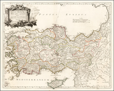
Map of Part of Kurdistan illustrating the Journeys & Researches of M. Consul Taylor is a significant map published in 1865 for the Journal of the Royal Geographical Society by J. Murray. This map traces the extensive travels and archaeological expeditions of John George Taylor, a British official of the Foreign Office who also made notable contributions as an early archaeologist in the Middle East. Known for his investigations of antiquities, Taylor was one of the pioneer archaeologists exploring the prominent burial mounds in the Persian Gulf region.
The son of Colonel R. Taylor, the British Assistant Political Agent in Basra from 1818 to 1822, John Taylor's career was deeply entrenched in Middle Eastern affairs. He served as an agent for the British East India Company and as the British Vice-Consul at Basra from 1851 to 1858. During his tenure, he acquired knowledge of the Mandaic language and scriptures under the instruction of the Mandaean high priest Adam Yuhana.
Following his service in Basra, Taylor was appointed the British Consul-General for Kurdistan and alternated his residence between Diyarbakir and Erzurum from 1859. His journeys and research within this role are vividly depicted on the map, with his routes marked in red. He published several of his travel reports in the Journal of the Royal Geographical Society, and in 1866, he was one of the first foreigners to venture into the Dersim area. His report on this journey remains an essential source on the history, geography, and anthropology of this area to date.
Notable on the map is Lake Van in the upper-right corner, the largest lake in Turkey, significant for its historical, ecological, and cultural relevance. The topography of the region, particularly the highly mountainous area to the southwest, is well-detailed using hachures to depict terrain elevations.
The map was engraved by Edward Weller, a British map engraver renowned for his detailed and accurate work. It is an important historical and geographical artifact, shedding light on Taylor's explorations and the geographical layout of a part of Kurdistan in the mid-19th century.

![Turcicum Imperium . . . [shows Cyprus]](https://storage.googleapis.com/raremaps/img/small/91206.jpg)