|
||

|

|
|

|
Rare First State
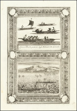
Finely colored example of the rare first state os Sebastian Munster's map of central Asia, one of tne of the great monster maps of the 16th century, showing three different imaginary human congenital malformations, as well as a one legged bird.
Munster's map shows three of the most famous medieval mythical creatures, which are based upon reports and myths which date to the early age of European Travel to the East, prior to Marco Polo's mid 13th Century travels in Asia. In addition, the map includes a scene showing Anthropophagus (cannibals) carving up a human torso. All these exotic features and creatures and more adorn Munster's map of Central Asia, north of India.
The map appeared the 1540 edition of Munster's Geographia, one of the most important works of the 16th Century. Sebastien Munster is generally regarded as one of the important map makers of the 16th Century.. Munster was a linguist and mathematician, who initially taught Hebrew in Heidelberg. He issued his first mapping of Germany in 1529, after which he issued a call geographical information about Germany to scholars throughout the country. The response was better than hoped for, and included substantial foreign material, which supplied him with up to date, if not necessarily accurate maps for the issuance of his Geographia in 1540.
Münster's 1540 Geographia deserves a number of superlatives. First, it established the convention that a world atlas should include world and continental maps. To that end, it was the first atlas to include specific maps of the Americas, Europe, Africa, and Asia. This change was in no small part influenced by the first circumnavigation of the globe by Ferdinand Magellan in 1522. The Geographia was the first printed work to render latitude and longitude in their now-standard degree-minute-second form. And it was the book that ushered in a series of "modern"-style world atlases culminating in the 1570 Theatrum Orbis Terrarum of Abraham Ortelius.
Sebastian Münster (1488-1552) was a cosmographer and professor of Hebrew who taught at Tübingen, Heidelberg, and Basel. He settled in the latter in 1529 and died there, of plague, in 1552. Münster made himself the center of a large network of scholars from whom he obtained geographic descriptions, maps, and directions.
As a young man, Münster joined the Franciscan order, in which he became a priest. He then studied geography at Tübingen, graduating in 1518. He moved to Basel, where he published a Hebrew grammar, one of the first books in Hebrew published in Germany. In 1521 Münster moved again, to Heidelberg, where he continued to publish Hebrew texts and the first German-produced books in Aramaic. After converting to Protestantism in 1529, he took over the chair of Hebrew at Basel, where he published his main Hebrew work, a two-volume Old Testament with a Latin translation.
Münster published his first known map, a map of Germany, in 1525. Three years later, he released a treatise on sundials. In 1540, he published Geographia universalis vetus et nova, an updated edition of Ptolemy’s Geographia. In addition to the Ptolemaic maps, Münster added 21 modern maps. One of Münster’s innovations was to include one map for each continent, a concept that would influence Ortelius and other early atlas makers. The Geographia was reprinted in 1542, 1545, and 1552.
He is best known for his Cosmographia universalis, first published in 1544 and released in at least 35 editions by 1628. It was the first German-language description of the world and contained 471 woodcuts and 26 maps over six volumes. Many of the maps were taken from the Geographia and modified over time. The Cosmographia was widely used in the sixteenth and seventeenth centuries. The text, woodcuts, and maps all influenced geographical thought for generations.