|
||

|

|
|

|
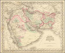
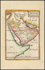
Conrad Malte-Brun's map of Western Asia, published in Paris in 1812, is a fascinating work by one of Europe's leading mapmakers of the early 19th Century. Focusing on Arabia, Persia, parts of Russia, and centering on the Caspian Sea, the map provides an insight into the cartographic techniques and geographical knowledge of the early 19th century.
Arabia, located in the southwest portion of the map, is detailed primarily through its desert landscapes. Key cities such as Mecca and Medina are marked, acknowledging the region's historical significance. "Kaueit ou Grain", Katif, Bahrain, Zibara and Macalat appear in the northern part of the peninsula, although the southern Emirate names are mostly lacking, with Meckchoan, Seer, Sehr and Iowassemis appearing in the region of modern Dubai and Abu Dhabi. The Red Sea is shown with a series of wavy lines, a common technique for depicting water bodies in older maps.
Persia is represented to the east of Arabia. The area's mountainous terrain, particularly the Zagros and Elburz ranges, are clearly outlined. Major cities, including the archaeological site of Persepolis, are marked, demonstrating the historical knowledge of the cartographer.
The Caspian Sea, the central point of the map, stands out due to its bright blue depiction, contrasting with the subdued tones of the land. The depiction of the sea includes many of its tributaries and coastal towns, suggesting the sea's importance in trade routes of the time.
The regions of Russia on the map are shown in varying tones of greens and browns. The path of the Volga River across the landscape and into the Caspian Sea is prominently marked. Significant cities, such as Moscow and Saint Petersburg, are given due importance with clear symbols and labels.