


|
||

|

|
|

|
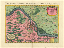
This scarce double-page engraving portrays two distinct yet connected geographical features of the Danube River: "Der Strudl" and "Der Wurbel." Originating from the mid-18th century, the work illustrates the turbulent water formations found along this crucial European waterway, rendered with attention to detail by Matthaus Seutter, an eminent cartographer and geographer based in Augsburg.
During the 18th century, the Danube, as Europe's second-longest river, served as a critical artery for commerce and communication. It traversed numerous political boundaries and linked diverse cultures, rendering its navigation both a practical necessity and a subject of academic interest. The two phenomena depicted - "Der Strudl" (The Whirlpool) and "Der Wurbel" (The Vortex) - were notorious challenges for river navigation, situated near the city of Ipsio, on the border of Upper and Lower Austria. They encapsulate the hazardous beauty of the river and the perils navigators faced, imbuing the engraving with an aura of dramatic intensity.
Matthaus Seutter, the creator of this engraving, was one of the leading cartographers in Augsburg during the first half of the 18th century. He was known for his precision and high-quality engravings that were often accompanied by elaborate decorative features. These two images uphold this tradition, showcasing Seutter's ability to balance accuracy in geographic representation with an aesthetically compelling composition.
The engraving provides a fascinating combination of topographical detail and interpretative illustration. Besides illustrating the physical phenomena of "Der Strudl" and "Der Wurbel," they also highlight the surrounding geographical features, like the nearby Chapel of Saint Nicholas. They serve not only as cartographical documents of the Danube's natural features but also as cultural artifacts that provide insights into the historical context in which they were created. The presence of these details reflects the human interaction with the river landscape, underscoring the interplay between nature and culture that defines the history of the Danube River.
Matthäus Seutter (1678-1757) was a prominent German mapmaker in the mid-eighteenth century. Initially apprenticed to a brewer, he trained as an engraver under Johann Baptist Homann in Nuremburg before setting up shop in his native Augsburg. In 1727 he was granted the title Imperial Geographer. His most famous work is Atlas Novus Sive Tabulae Geographicae, published in two volumes ca. 1730, although the majority of his maps are based on earlier work by other cartographers like the Homanns, Delisles, and de Fer.
Alternative spellings: Matthias Seutter, Mathaus Seutter, Matthaeus Seutter, Mattheus Seutter

![(First state!) Lacus Constantiensis XX Tab Nova [The Bodensee]](https://storage.googleapis.com/raremaps/img/small/94703.jpg)