|
||

|

|
|

|
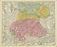
"Potentia Archiducum Austriae sive Circuli Austriaci delineatio," or "The Power of the Archdukes of Austria or the Delineation of the Austrian Circle," is an intricate map published around 1760 in Augsburg by Conrad Tobias Lotter. Providing a detailed representation of the region of Austria, the map spans a significant geographical area extending from Bohemia Regnum in the north to the Bishoprick of Istria, the Duchy of Carinthia, and the Duchy of Carniola in the south. The map is centered on the Salzburg Archbishoprick, and stretches from Switzerland in the west to Styria in the east.
The Comitatus of Tyrolia and Comitatus of Styria are central to the map. A "Comitatus" refers to the domain governed by a count or countess, denoting a significant administrative unit within the Austrian Empire. Tyrolia, known today as Tyrol, was a significant region in the western part of Austria, while Styria was a southeastern duchy that was part of the Inner Austrian lands in the Habsburg Monarchy.
Among the smaller regions depicted on the map are Brisgovia Austriac, Ortonavia, Praefect Suevaia, Brigantus Comitatus, and Marchionat Burgau Austriac.
-
Brisgovia Austriac: This refers to the Austrian Breisgau, a territory in the south-western part of the Holy Roman Empire, which was an Austrian possession at the time the map was published. It is located in what is now the southwestern part of Germany.
-
Ortenavia: Ortenavia likely refers to the Ortenau area, a region in the southwestern part of Germany, close to the French border. During the map's time period, this area was part of the Holy Roman Empire.
-
Praefect Suevaia: The Praefect Suevaia probably refers to Swabia, a region in southwest Germany within the Holy Roman Empire. This area had many ties to Austria through the Habsburg dynasty.
-
Brigantus Comitatus: Brigantus may refer to the city of Bregenz, which was part of the county of Tyrol in the Habsburg Monarchy.
-
Marchionat Burgau Austriac: The Marchionat Burgau refers to the Margraviate of Burgau, an area on the eastern border of Swabia, which was controlled by the Habsburgs from the 14th century onwards.
This map provides a snapshot of the Austrian Circle during the mid-18th century, an era characterized by the increasing centralization of power by the Habsburg monarchy and the complex web of territories that made up the Holy Roman Empire. It beautifully encapsulates the richness and diversity of the regions under the Austrian Archdukes' control during this period. Through its elaborate details and precise delineations, it offers valuable insights into the political, administrative, and territorial realities of the time.
Tobias Conrad Lotter (1717-1777) is one of the best-known German mapmakers of the eighteenth century. He engraved many of the maps published by Matthaus Seutter, to whose daughter Lotter was married. He took over Seutter’s business in 1756. Lotter’s son, M. A. Lotter, succeeded his father in the business.
![[Nové Zámky/Érsekújvár] Abris der Festung Neuheusel Wie solche von Kay May: Armada underm General Bocquoy Belagert gewesen](https://storage.googleapis.com/raremaps/img/small/75327.jpg)
![Bohemia In Suas Partes Geographice Distincta Petrus Kaerius Caelavit (Carte-a-figures edition) [Bohemia Divided Into Its Geographic Parts, Engraved by Peterus Kaerius]](https://storage.googleapis.com/raremaps/img/small/80057.jpg)