|
||

|

|
|

|
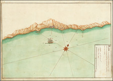
The manuscript map titled "Plan du mouillage d'altea a la Cote despagne ou iI y a une belle aiyade les ancres les mouillages," dating back to around 1770, offers a fascinating insight into maritime navigation and coastal geography during the late 18th century.
The illustration depicts Altea, a location on the Spanish Costa Blanca, noted for its impressive bay, as suggested by the title. The map includes several drawings that provide a visual representation of the coastal topography. Among these are depictions of coastal mountains that tower over the region, embodying both the natural beauty and challenging geography of the area.
The settlements or towns along the coastline are also displayed, possibly offering valuable information about population distribution, significant landmarks, or habitation patterns during that period. These illustrations, no doubt, would have served as essential markers for navigators during their voyages.
Prominently displayed on the waters are three square-rigged ships, indicative of the sea vessels that were widely used during the era. These depictions not only add aesthetic value to the map but also convey historical information about the types of ships used in maritime voyages of the time.
One of the notable technical aspects of the map are the soundings near the anchorage. These soundings, which measure the depth of water, were critical navigational tools, helping sailors to avoid shallow areas and potential hazards, especially around an anchorage.
All these elements combine to create not just a utilitarian tool for sailors of the period but also a rich historical document for modern-day viewers, giving us an insight into the maritime practices, geography, and artistic conventions of map-making in the late 18th century.
![(Northern Spain) Legionis, Biscaiae et Guipiscoae Typus [Map of León, Biscay, and Gipuzkoa.]](https://storage.googleapis.com/raremaps/img/small/98957.jpg)