


|
||

|

|
|

|
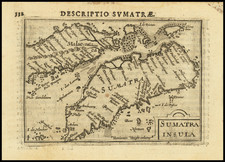
A Chart of the West Coast of Sumatra From Old Bencoolen to Buffaloe Point Containing The Road of Bencoolen and Poolo Bay is a detailed maritime chart after information provided by Captain Joseph Huddart, with contributions from John Price in 1787 and Mr. McDonald in 1793. Published on 1 March 1797 by Laurie & Whittle, the chart showcases a thorough exploration of the Sumatran coastline during a significant era of maritime navigation and trade.
In addition to the main chart, the sheet also includes two subordinate plans: Plan of Rat Island and Plan of Poolo Bay, both by Captain Huddart. These detailed plans further underline the comprehensive navigational information provided by this document, demonstrating the extent of maritime exploration of the region during this period.
The chart is marked by numerous annotations detailing various anchorages along the Sumatran coastline, signifying the heightened navigation activities in the region and their importance to maritime traders and explorers. Prominently depicted is Fort Marlborough on Sumatra, a significant English stronghold in the region, providing insight into the strategic interests of the period.
In the context of the late 18th century, this chart reflects the prevalent maritime exploration and trade interests, specifically those associated with the English presence in the region. It stands as an integral document, highlighting the intricacies of maritime navigation and territorial strategy of its time. Through a detailed examination of this chart, one gains insights into the maritime practices and geopolitical contexts that shaped this historical epoch.
Robert Laurie (ca. 1755-1836) and James Whittle (1757-1818) formed their Fleet Street, London-based firm upon the 1794 death of their employer Robert Sayer, himself one of the dominant print and mapmakers of the last half of the 18th century.
Laurie & Whittle started managing Sayer's business as early as 1787. They took over all managerial duties when Sayer's health flagged in 1792, and they changed the imprint in 1794 upon his death. Sayer left the two a 21-year lease on the shop (at £100 a year) and on Sayer's Bolt Court premises, as well as an option to acquire stock and equipment at a preferential price of £5,000 payable over three years.
Robert Laurie retired from the firm in 1812, and his role was assumed by his son, Richard Holmes Laurie (1777-1858). The younger Laurie worked with James Whittle until the latter died in 1818. After R. H. Laurie died in 1858, Alexander George Findlay, FRGS (1812-1875) purchased the firm from his daughters. The firm continues today under another name, specializing in yachting charts.
Laurie & Whittle were prolific print and map publishers, and throughout their careers, they produced numerous very important and rare works. They carried on Robert Sayer's atlas business and were responsible for editions of The Complete East-India Pilot and The American Atlas.

![[ Bangka Strait ] Plan of the Straits of Banca Surveyed by Captn. Lloyd of the Elliot Country Ship and Mr. Bampton in his Passage from China to Batavia and from Batavia to Malaca . . . 1796](https://storage.googleapis.com/raremaps/img/small/94800.jpg)