|
||

|

|
|

|
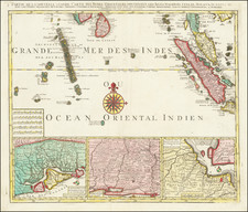
The South Part of the Straits of Malacca inscribed to Captn. G. G. Richardson, by Captn. J. Lindsey, dated 1798, is a significant nautical map by English maritime publishers Robert Laurie and James Whittle. This chart showcases the southern part of the Malay Peninsula and surrounding islands from Malacca, the region's primary trading port at the time, south past Singapore Island, to Poolo Bintang, and Point Romania. It also includes parts of Sumatra, as well as various mountains along the coast such as Mount Moar, Mount Formoso, Mount Battou Batou, and Jahore Hill. Several islands, including Singapore (Sincapour), Tooly, Salat Booro, Great Carimon, Little Carimon, Poolo Battam, and Poolo Bintang are indicated, with numerous depth soundings and shoals, reefs, and other underwater hazards clearly marked.
During the late 18th century, these straits were a crucial trade route despite the fact that the British had not yet settled on the island of Singapore. The East Indian spice trade was at its peak during this time, transforming corporations like the British East India Company into global powers. This map, which initially appeared in the manuscript journals of British hydrographer Joseph Huddard, who mapped part of the coast of Sumatra in 1778 and 1779, underwent numerous revisions before realizing its present form under Laurie and Whittle in 1798.
The publishers, Laurie and Whittle, were successors to the Robert Sayer firm, and were known for their significant contributions to the field of map and atlas publishing during the late 18th and early 19th century. They were instrumental in updating and modifying existing Sayer plates and collaborating with other noteworthy cartographers of their era. Their publishing house and printing stock continue to thrive today as Imray, Laurie, Norie and Wilson Ltd., the oldest surviving chart publisher in Europe. This map is drawn from their publication The East-India Pilot, or Oriental Navigator (1799 or 1800), which contains a comprehensive collection of charts and plans for navigation not only of the Indian and China Seas, but also between England and the Cape of Good-Hope.
Robert Laurie (ca. 1755-1836) and James Whittle (1757-1818) formed their Fleet Street, London-based firm upon the 1794 death of their employer Robert Sayer, himself one of the dominant print and mapmakers of the last half of the 18th century.
Laurie & Whittle started managing Sayer's business as early as 1787. They took over all managerial duties when Sayer's health flagged in 1792, and they changed the imprint in 1794 upon his death. Sayer left the two a 21-year lease on the shop (at £100 a year) and on Sayer's Bolt Court premises, as well as an option to acquire stock and equipment at a preferential price of £5,000 payable over three years.
Robert Laurie retired from the firm in 1812, and his role was assumed by his son, Richard Holmes Laurie (1777-1858). The younger Laurie worked with James Whittle until the latter died in 1818. After R. H. Laurie died in 1858, Alexander George Findlay, FRGS (1812-1875) purchased the firm from his daughters. The firm continues today under another name, specializing in yachting charts.
Laurie & Whittle were prolific print and map publishers, and throughout their careers, they produced numerous very important and rare works. They carried on Robert Sayer's atlas business and were responsible for editions of The Complete East-India Pilot and The American Atlas.
![(First Printed Plan of Singapore) Plan of the British Settlement of Singapore. by Capt. Franklin & Lieut. Jackson [on sheet with:] Plan of the Town of Singapore by Lieut. Jackson](https://storage.googleapis.com/raremaps/img/small/102820.jpg)
![Asiatic Archipelago [Early Singapore Inset]](https://storage.googleapis.com/raremaps/img/small/66879.jpg)