|
||

|

|
|

|
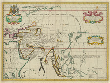
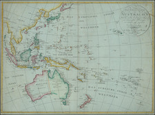
A New Chart of the China Sea, published by Laurie & Whittle in 1794, embodies a fascinating conjunction of navigation, maritime exploration, and global commerce, centering around the South China Sea. The chart's notable sea tracks, coastal profiles, and detailed soundings lend it a significant stature in maritime history. The inclusion of observations from the extensive trading activities of the English East India Company (EIC) in the region lends the chart additional historical importance.
At the time of the chart's creation, the world was in the throes of the Napoleonic Wars, and the British Empire was expanding its spheres of influence. The EIC, an instrument of this imperial ambition, was extending its operations from the Indian Subcontinent into the South China Sea. This chart, rich with the navigational intelligence gathered from ships employed by the EIC, marks an era of intensive exploration and territorial acquisitions. Its publication date coincides with the aggressive expansion of the British Empire in the region, culminating in the establishment of Singapore by Stamford Raffles in 1819, and the permanent British presence in Malaya from 1824.
The A New Chart of the China Sea depicts an extensive area, including key coastlines of China, Taiwan, the Philippines, Vietnam, Cambodia, the Malay Peninsula, Borneo, Sumatra, and Celebes. Additionally, it delineates the future sites of influential port cities like Hong Kong and Singapore, highlighting the prescient geographical understanding of its creators. In conjunction with the labeling of sea tracks, such as the "Track of the Pitt Capt. E. Manning Towards China 1789", and the inclusion of coastal profiles, this sea chart affords an in-depth perspective of the maritime operations in the region during the late 18th century.
Lastly, this chart holds a place of distinction in Laurie & Whittle's East India Pilot, or, Oriental Navigator. This maritime atlas, published in various editions from 1794 onwards (and before that under the auspices of Laurie & Whittle's predecessor, Robert Sayer), was instrumental for navigation in East Asia during this era. The exceptional access that Robert Laurie and James Whittle had to the latest manuscript charts arriving from Asia makes this piece not only an artifact of remarkable historical interest, but also a compelling testament to the interplay between exploration, commerce, and geopolitical ambitions.
The chart contains three informative insets that augment its maritime utility. In the upper-left corner, "The Islands and Coasts Between S Johns and The Great Ladrone" by Captain John Paskall Larkins presents a focused study of this critical region, with a further enlargement of "Shitoe Bay". Positioned center left is "A Sketch of Northumberland Straits 1783" by Captain Rees, providing an invaluable supplement to understanding this specific strait.
Robert Laurie (ca. 1755-1836) and James Whittle (1757-1818) formed their Fleet Street, London-based firm upon the 1794 death of their employer Robert Sayer, himself one of the dominant print and mapmakers of the last half of the 18th century.
Laurie & Whittle started managing Sayer's business as early as 1787. They took over all managerial duties when Sayer's health flagged in 1792, and they changed the imprint in 1794 upon his death. Sayer left the two a 21-year lease on the shop (at £100 a year) and on Sayer's Bolt Court premises, as well as an option to acquire stock and equipment at a preferential price of £5,000 payable over three years.
Robert Laurie retired from the firm in 1812, and his role was assumed by his son, Richard Holmes Laurie (1777-1858). The younger Laurie worked with James Whittle until the latter died in 1818. After R. H. Laurie died in 1858, Alexander George Findlay, FRGS (1812-1875) purchased the firm from his daughters. The firm continues today under another name, specializing in yachting charts.
Laurie & Whittle were prolific print and map publishers, and throughout their careers, they produced numerous very important and rare works. They carried on Robert Sayer's atlas business and were responsible for editions of The Complete East-India Pilot and The American Atlas.