|
||

|

|
|

|
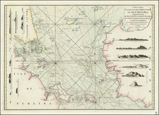
A New Chart of the West Coast of Sumatra, published by Laurie & Whittle in 1794, provides a comprehensive look at the western coastal geography of this large Indonesian island from the Equator to the Straits of Sunda. Enhanced with significant additions and revisions drawn from the surveys of Captain Huddart, Captain Whiteway, and Mr. John Price among other navigators, this chart was a pivotal resource for sailors navigating these waters in the late 18th century.
This intricate chart features several inset maps, adding further detail to key locations. Notably, a plan of Padang, the primary Dutch settlement on the west coast of Sumatra, is included. This detail, borrowed from Van Keulen, allows viewers to gain a closer look at the colonial influence and infrastructural layout in this area.
Another inset is the detailed plan of Indrapour by J. Van Hout, offering a more localized view of this particular region. The third inset depicts the Straits of Se Cockup, situated between the islands of North and South Poggy, based on the survey by Joseph Mascall, a volunteer in 1773. This inset not only maps the straits but also provides navigational advice for sailors, pointing out the best places to anchor without causing damage to cables or anchors. It also advises on the locations for freshwater and the presence of strong currents. It informs sailors about the rocky and narrow entrance on the northeast side, and the clear, wide entrance on the southeast side.
This chart, like other maritime charts of the time, was not only a navigational tool, but also an informational document. It combines geographical details with practical sailing advice, serving as a comprehensive guide for seafarers. It encapsulates a snapshot of the maritime knowledge of the time and reflects the interactions between European colonizers and the geography of foreign lands like Sumatra.
Robert Laurie (ca. 1755-1836) and James Whittle (1757-1818) formed their Fleet Street, London-based firm upon the 1794 death of their employer Robert Sayer, himself one of the dominant print and mapmakers of the last half of the 18th century.
Laurie & Whittle started managing Sayer's business as early as 1787. They took over all managerial duties when Sayer's health flagged in 1792, and they changed the imprint in 1794 upon his death. Sayer left the two a 21-year lease on the shop (at £100 a year) and on Sayer's Bolt Court premises, as well as an option to acquire stock and equipment at a preferential price of £5,000 payable over three years.
Robert Laurie retired from the firm in 1812, and his role was assumed by his son, Richard Holmes Laurie (1777-1858). The younger Laurie worked with James Whittle until the latter died in 1818. After R. H. Laurie died in 1858, Alexander George Findlay, FRGS (1812-1875) purchased the firm from his daughters. The firm continues today under another name, specializing in yachting charts.
Laurie & Whittle were prolific print and map publishers, and throughout their careers, they produced numerous very important and rare works. They carried on Robert Sayer's atlas business and were responsible for editions of The Complete East-India Pilot and The American Atlas.
![[ Bangka Strait ] Plan of the Straits of Banca Surveyed by Captn. Lloyd of the Elliot Country Ship and Mr. Bampton in his Passage from China to Batavia and from Batavia to Malaca . . . 1796](https://storage.googleapis.com/raremaps/img/small/94800.jpg)