


|
||

|

|
|

|
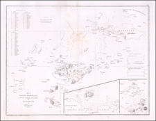
One of the great 18th-century English charts of the Philippines, this map offers an in-depth navigational account of a significant swath of the Southeast Asian seascape. First published by Robert Sayer in 1778, and here republished by Laurie & Whittle in 1794, the chart draws upon multiple sources, including an original drawing from Captain Robert Carr and the famous 1734 map by Pedro Murillo de Velarde, to deliver a comprehensive depiction of the marine corridor between Canton and Balambangan.
The late 18th century was a period of intense global exploration and trade, with burgeoning maritime routes crisscrossing the oceans. The China Sea and its surrounding archipelagos held particular significance in this global network due to their strategic location between the key trading hubs of China, Southeast Asia, and the West. This chart offers a tangible record of these important sea routes, including the soundings, shoals, and rocks that would have been vital navigational information for sailors of the time.
The chart also embodies a convergence of cartographic practices and traditions. It integrates knowledge drawn from multiple sources, reflecting the collaborative and often multinational nature of cartographic knowledge production during this era. The inclusion of data from Captain Carr's original drawing alongside that of Pedro Murillo de Velarde's map signals a careful process of comparison and synthesis aimed at achieving accuracy and comprehensiveness.
Two inset maps provide focused views of the Ports of Ylocos and the Bay of Subic, both situated on the west coast of Luzon. These insets lend a more granular level of detail to specific areas of interest, further enhancing the chart's utility for navigational purposes.
In its totality, A Chart of the China Sea, and Philippine Islands represents a significant cartographic accomplishment of the late 18th century. It not only delivers valuable navigational information but also encapsulates the collaborative, global endeavor of mapping the world's waterways during a time of expanding global exploration and commerce.
Anson's Capture of the Nuestra Señora de Cavadonga
A prominent feature of the map is the depiction of "the Spanish Galeon, Nostra Señora de Cabadonga taken by the Centurion June the 20 1743". This illustration, marking a significant event in naval history, offers an insight into the intense maritime conflicts of the era.
Commodore George Anson's pursuit of the Manila galleon Nuestra Señora de Covadonga lends a riveting episode to the annals of naval warfare, emblematic of the fierce competition between England and Spain during the War of the Austrian Succession (1740-1748). Commanding a squadron of six ships, Anson embarked on a mission to disrupt Spanish interests in the Pacific, a strategic theater where the two maritime powers jostled for supremacy. With the Centurion as his flagship, Anson braved the tumultuous seas around Cape Horn, reaching Macao, China, in November 1742. Yet, the Centurion was the only ship remaining from his original squadron, with the others lost to the exigencies of the journey.
After wintering in Macao, Anson resumed his quest, setting his sights on the Nuestra Señora de Covadonga, an immensely valuable Manila galleon. In June 1743, while navigating through Philippine waters, he spotted his target. The ensuing battle witnessed the Spaniards attempting to jettison part of their cargo to hasten their escape - a futile effort that culminated in the Covadonga surrendering its vast treasure of Spanish dollars, silver, and other precious goods to the Centurion.
This seizure marked a pivotal point in Anson's expedition, not only ensuring the financial success of his voyage but also catapulting him to a life of affluence. The depiction of this dramatic encounter on the chart resonates with the tumult and triumph inherent in the historical narrative of maritime exploration and warfare during this period.
Robert Laurie (ca. 1755-1836) and James Whittle (1757-1818) formed their Fleet Street, London-based firm upon the 1794 death of their employer Robert Sayer, himself one of the dominant print and mapmakers of the last half of the 18th century.
Laurie & Whittle started managing Sayer's business as early as 1787. They took over all managerial duties when Sayer's health flagged in 1792, and they changed the imprint in 1794 upon his death. Sayer left the two a 21-year lease on the shop (at £100 a year) and on Sayer's Bolt Court premises, as well as an option to acquire stock and equipment at a preferential price of £5,000 payable over three years.
Robert Laurie retired from the firm in 1812, and his role was assumed by his son, Richard Holmes Laurie (1777-1858). The younger Laurie worked with James Whittle until the latter died in 1818. After R. H. Laurie died in 1858, Alexander George Findlay, FRGS (1812-1875) purchased the firm from his daughters. The firm continues today under another name, specializing in yachting charts.
Laurie & Whittle were prolific print and map publishers, and throughout their careers, they produced numerous very important and rare works. They carried on Robert Sayer's atlas business and were responsible for editions of The Complete East-India Pilot and The American Atlas.


![[Manila Bay] La Baie de Manille, Selon les Observations les plus recentes . . .](https://storage.googleapis.com/raremaps/img/small/59286.jpg)