|
||

|

|
|

|
Rare Early Central Pacific Map and Time Table
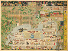
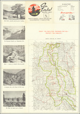
The "Map of the Central Pacific Railroad and its Connections," published in May 1871, is a tangible embodiment of the industrial progress and the geographical diversity that characterized the American West in the late 19th century. The map serves as a visual testament to the growth and influence of the Central Pacific Railroad, presenting a detailed representation of its route extending from the Midwest to San Francisco.
The Central Pacific Railroad was one of the two rail networks, the other being the Union Pacific, that completed the first transcontinental railroad in 1869. It was chartered by Congress in 1862 and backed by substantial federal land grants. Starting from Sacramento, California, it was built eastwards, overcoming the challenging terrain of the Sierra Nevada mountains. By 1869, it had successfully linked up with the Union Pacific line at Promontory Point, Utah, facilitating coast-to-coast travel and ushering in a new era of westward expansion.
This 1871 map illustrates the result of this expansion two years after the railroad's completion. It traces the route from Omaha and Kansas City (via Denver), moving west to Cheyenne, and then converging into a single line towards Sacramento and Stockton. From there, the lines branch off towards San Francisco and extend further south into Southern California, and north into Oregon.
Encircling the map are 24 woodcut images depicting scenes along the route, including natural wonders such as canyons, rivers, and the imposing Summit of the Sierras. They serve as a visual chronicle of the landscapes traversed by the railroad. Noteworthy among them is the depiction of a Hydraulic Gold mining scene, a stark reminder of the gold rush that played a significant role in California's development and the subsequent demand for better transportation networks.
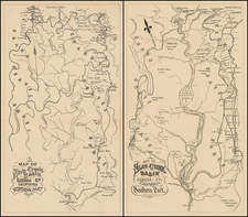
On the verso of the map, one finds a smaller map titled "Map of the Rail & State Route to Big Tree Groves and Yosemite." It's accompanied by timetables and promotional data for the Central Pacific and other lines, providing logistical details and underscoring the commercial aspects of the railroad.
In sum, the map of the Central Pacific Railroad and its Connections reflects not just the geographical realities of the time but also the momentum of progress that was the hallmark of the era. It visually encapsulates the narrative of the Central Pacific Railroad up until 1871 - a tale of industrial ingenuity, economic growth, and the taming of the vast American West.