


|
||

|

|
|

|
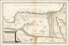
Fezzae et Marocchi Regna Africa Celeberrima, a striking cartographic representation of the Kingdoms of Marocchi and Fessae (modern-day Morocco), was beautifully rendered by Willem Janszoon Blaeu in Amsterdam, circa 1640. Based on the cartographic work of Abraham Ortelius, this map presents a detailed illustration of one of Africa's most famed regions during the 17th century.
The map is a testament to Blaeu's mastery of the cartographer's art, capturing the diverse landscapes of the region with precision and elegance. It meticulously delineates key geographical features, such as mountains, rivers, and lakes, and highlights significant urban centers like Marrakesh, Taradante, and Fez. Tangier, Ceuta, and Rio Rabata, prominent in the historical trade routes of the era, are also distinctly marked.
Blaeu's portrayal of large fortified towns reflects the strategic importance of these settlements in an era of active maritime exploration and colonial expansion. This detail offers valuable insights into the sociopolitical dynamics of the time and provides a context for understanding the region's historical development.
The map features a large, ornate cartouche, characteristic of Blaeu's decorative style. This embellishment, along with the inclusion of sailing ships, infuses the map with an evocative maritime theme, reminiscent of the Age of Discovery. The credit to Abraham Ortelius in the title acknowledges the renowned cartographer's contribution and attests to the enduring influence of his work.
Fezzae et Marocchi Regna Africa Celeberrima is not just a map; it is a piece of art and a historical document that beautifully encapsulates the geographical understanding and aesthetic sensibilities of 17th-century cartography.
Willem Janszoon Blaeu (1571-1638) was a prominent Dutch geographer and publisher. Born the son of a herring merchant, Blaeu chose not fish but mathematics and astronomy for his focus. He studied with the famous Danish astronomer Tycho Brahe, with whom he honed his instrument and globe making skills. Blaeu set up shop in Amsterdam, where he sold instruments and globes, published maps, and edited the works of intellectuals like Descartes and Hugo Grotius. In 1635, he released his atlas, Theatrum Orbis Terrarum, sive, Atlas novus.
Willem died in 1638. He had two sons, Cornelis (1610-1648) and Joan (1596-1673). Joan trained as a lawyer, but joined his father’s business rather than practice. After his father’s death, the brothers took over their father’s shop and Joan took on his work as hydrographer to the Dutch East India Company. Later in life, Joan would modify and greatly expand his father’s Atlas novus, eventually releasing his masterpiece, the Atlas maior, between 1662 and 1672.

![[Moroccan Coast -- Agadir, Essaouira, Safi] Afbeeldinge nae't leven der Zeecusten van Barbarien, van de C. Cantin zuijdwaert tot verbij de C. de Geer, mitsgaders de gelegentheijt van't eijlant Mogodor, alles op zijne rechte Streckinge en hoochte gestelt](https://storage.googleapis.com/raremaps/img/small/62163.jpg)