|
||

|

|
|

|
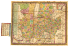
Nice example of J.D. Lake's map of Brooklyn, Cleveland, from his 187 Illustrated Atlas of Cuyahoga County Ohio.
The map, hand-colored, encapsulates the charm and historical essence of Cleveland and West Cleveland. The map stretches north to Lake Erie. The bustling townships and neatly parceled plots of land are each depicted with great detail, offering an impressive level of geographic specificity. The built environment's existence at the time, including structures, roads, and landmarks, are tastefully portrayed using hues that distinguish between the neighborhoods.
Outside of the densely-populated areas, landowners are shown for larger parcels of land. The map extends southward to the community of Brighton, demonstrating the city's expansion during the period. Brighton, portrayed with the same care and precision as the rest of the map, exhibits a charming mix of residential and agricultural land uses.
![[Edwinburgh, Ohio] (Millsboro Township, Richland County)](https://storage.googleapis.com/raremaps/img/small/66072.jpg)