


|
||

|

|
|

|
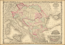
An intriguing early 18th-century map by Herman Moll, depicting the Balkans region under Ottoman control, extending from the Black Sea to Slovenia, Croatia, and Dalmatia. This map provides a valuable historical snapshot of the geographical and political landscape of Southeast Europe during the height of the Ottoman Empire.
Herman Moll, a leading figure in London's mapmaking industry in the early 18th century, was known for his accurate and detailed cartographic works. This map of the northern part of the Ottoman Empire in Europe, titled "The North Part of Turky in Europe Slavonia &c.", stands as a testament to his meticulous craftsmanship and attention to geopolitical detail.
The map provides a comprehensive view of the region at a time when the Ottoman Empire, one of the world's most powerful states during the 15th and 16th centuries, had a significant hold over Southeast Europe. The territories of present-day Slovenia, Croatia, and Dalmatia, along with the expansive coastline of the Black Sea, are clearly demarcated, reflecting the vast reach of Ottoman influence.
Moreover, this map illuminates the fluid nature of national borders, underscoring the constant shifts in power and territory that characterize the history of the Balkans. As such, it serves as an important cartographic document, allowing contemporary viewers to trace the historical progression of this diverse and dynamic region.
In its geographical precision and historical resonance, Moll's map offers not only a window into the complex past of Southeast Europe but also stands as a testament to the enduring art and science of mapmaking.
Herman Moll (c. 1654-1732) was one of the most important London mapmakers in the first half of the eighteenth century. Moll was probably born in Bremen, Germany, around 1654. He moved to London to escape the Scanian Wars. His earliest work was as an engraver for Moses Pitt on the production of the English Atlas, a failed work which landed Pitt in debtor's prison. Moll also engraved for Sir Jonas Moore, Grenville Collins, John Adair, and the Seller & Price firm. He published his first original maps in the early 1680s and had set up his own shop by the 1690s.
Moll's work quickly helped him become a member of a group which congregated at Jonathan's Coffee House at Number 20 Exchange Alley, Cornhill, where speculators met to trade stock. Moll's circle included the scientist Robert Hooke, the archaeologist William Stuckley, the authors Jonathan Swift and Daniel Defoe, and the intellectually-gifted pirates William Dampier, Woodes Rogers and William Hacke. From these contacts, Moll gained a great deal of privileged information that was included in his maps.
Over the course of his career, he published dozens of geographies, atlases, and histories, not to mention numerous sheet maps. His most famous works are Atlas Geographus, a monthly magazine that ran from 1708 to 1717, and The World Described (1715-54). He also frequently made maps for books, including those of Dampier’s publications and Swift’s Gulliver’s Travels. Moll died in 1732. It is likely that his plates passed to another contemporary, Thomas Bowles, after this death.
![(Adriatic & Balkans) Tabula V Europae [Title on verso]](https://storage.googleapis.com/raremaps/img/small/102703.jpg)
![Natolia, quae olim Asia Minor [shows Cyprus]](https://storage.googleapis.com/raremaps/img/small/86389.jpg)
![Turkey in Europe [Including Greece and the Balkan Peninsula]](https://storage.googleapis.com/raremaps/img/small/76200.jpg)
![Asia Minor [Shows Cyprus]](https://storage.googleapis.com/raremaps/img/small/43185.jpg)