|
||

|

|
|

|
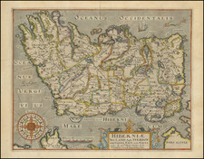
Striking full color example of Mercator's map of the County Carlow region of southeastern Ireland, with decorative cartouche.
Mercator's map of County Carlow is a meticulous portrayal of the region's geographical features, bringing to life the towns, rivers, mountains, and forests of this southeastern Irish county. Among the region's natural features, the rivers Barrow and Slaney stand out. The Barrow, the second-longest river in Ireland, flows gracefully through the landscape, its winding course faithfully represented. The Slaney, though smaller, also plays a significant role in the region's hydrography, its tributaries reaching into the county's heartlands. These rivers are not just physical features; they're lifelines that have shaped the county's history and its residents' lives.
The map also acknowledges the county's rich woodland heritage, depicting forests that once covered large parts of the landscape. While precise forest mapping is a challenge in historical cartography, the inclusion of these wooded areas is a testament to their significance in the local ecology and economy.
The largest towns noted on the map are Catherlagh (Carlow) and Laghlyn (Leighlinbridge) and Clough Grenant (unidentified). As the administrative and economic hub, Carlow is a focal point in the county's geography.
Gerard Mercator is one of the most famous cartographers of all time. Mercator was born in Flanders and educated at the Catholic University in Leuven. After his graduation in 1532, Mercator worked with Gemma Frisius, a prominent mathematician, and Gaspar a Myrica, a goldsmith and engraver. Together, these men produced globes and scientific instruments, allowing Mercator to hone his skills.
With his wife, Barbara, Mercator had six children: Arnold, Emerentia, Dorothes, Bartholomeus, Rumold, and Catharina. In 1552, Mercator moved to Duisburg from Leuven, where he lived for the rest of his life. In 1564, he was appointed the official cosmographer to the court of Duke Wilhelm of Cleve.
Mercator’s most important contribution was the creation and popularization of a projection which now bears his name. On Mercator projection maps, all parallels and meridians are drawn at right angles to each other, with the distance between the parallels extending towards the poles. This allowed for accurate latitude and longitude calculation and also allowed navigational routes to be drawn using straight lines, a huge advantage for sailors as this allowed them to plot courses without constant recourse to adjusting compass readings.
Mercator’s other enduring contribution to cartography is the term “atlas”, which was first used to describe his collection of maps gathered in one volume. The Mercator atlas was published in 1595, a year after Mercator’s death, thanks to the work of his sons, particularly Rumold, and his grandsons.
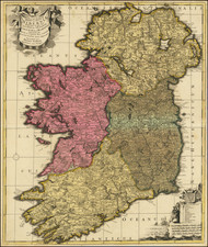
![[ Ireland ] Hiberniae Regnum tam in praecipuas Ultoniae, Connaciae, Lageniae, et Momoniae. . .](https://storage.googleapis.com/raremaps/img/small/78023.jpg)