|
||

|

|
|

|
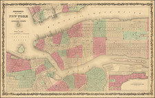
One of the Earliest Printed Maps of New York City
Detailed Revolutionary War Plan of New York City, published in the November, 1776 edition of the Universal Magazine, capturing its nascent urban development and pastoral outskirts.
The Universal Magazine plan of the City of New York is among the earliest obtainable maps of New York City. Appearing only 13 years after Bellin's Ville De Manath ou Nouvelle-Yorc, the earliest obtainable map of New York City, the Universal Magazine map is an important early map of the City, being perhaps the first widely distributed map of New York City in English and an important synthesis the earlies work of Montressor and Ratzer.
The map is a combination of the maps of Montresor (1766) and Ratzen (1767) maps, but with some new additions and details, including the addition of the name Delaney's New Square to an area near the Collect Pond (labeled here Fresh Water) that is surrounded by blocks of New Buildings not Finished. The square which appeared on the Ratzen map as the Great Square is filled now no longer vacant and has been filled in with buildings.
The map names many streets and roads, including Broadway and the "Road to King's Bridge where the Rebels mean to make a Stand," which runs parallel to "Road to Kepps Bay where the Kings Troops Landed." It also includes details of wharves, ferries, public buildings, some industries, orchards, gardens, fields, houses (including some residents' names), Fort George, and the Battery. The map also covers what was then the rural part of Manhattan Island up to present-day 14th Street and small parts of Long Island.
The cartographic portrayal of "Delaney's New Square," with its grid of buildings marked as "New Buildings not Finished," speaks to the optimism and ambition of a city on the threshold of transformation, highlighting New York's relentless push towards modernization even in the midst of war. These embryonic building blocks would eventually evolve into the city's iconic grid structure, a design element that has become synonymous with Manhattan.
The inclusion of pastoral elements, such as farmland and the modest grouping of buildings near the "Brookland Ferry," stands in stark contrast to the city's contemporary skyscape. This incongruity underscores the profound changes that have swept across the city since the late 18th century. Viewed through the lens of history, this map serves as a testament to New York City's dynamic evolution, showcasing the dramatic transformation from an agrarian society to the densely populated, bustling metropolis it is today.
While the map is not rare, it has become increasingly scarce on the market.
![[New York Harbor]](https://storage.googleapis.com/raremaps/img/small/78897.jpg)