|
||

|

|
|

|
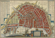
This map, published by Pieter van der Aa in 1725, offers a detailed representation of Amsterdam during a period of notable expansion and fortification. As a largely consolidated version of Cornelis Anthonisz's wall map of 1544, this work distills the cityscape to its major public structures, offering a streamlined view of Amsterdam's key features.
This period of the late 15th century was one of transformative growth for Amsterdam. The city, initially contained within stone walls in 1482, was on the verge of its golden age. Van der Aa's map, therefore, offers an invaluable glimpse into this formative period. It presents a city in the process of expanding its boundaries and solidifying its urban identity, just before the influx of wealth and cultural influence that would define its golden age.
While the Anthonisz map delivers a bird's-eye perspective of the city with all buildings represented, van der Aa's map concentrates on major public landmarks. This focus on important structures provides an effective overview of the city's layout and the significant elements of its urban fabric. Included in this pictorial record are key architectural features such as Reguliers Poort, Selle-Suffers, Voet boogs Doelen, and Haerlemmer Sluys, among others, lending the map a certain historical and architectural richness.
Overall, Pieter van der Aa's map of Amsterdam stands as a cartographic document of a city on the cusp of a transformative era. It illuminates the architectural and urban milestones that formed the basis of the city's growth, setting the stage for the flourishing golden age to come. The map's emphasis on major structures, combined with the historical context it provides, creates a valuable and insightful visual archive of Amsterdam during this pivotal period.
Pieter van der Aa (1659-1733) was a Dutch mapmaker and publisher who printed pirated editions of foreign bestsellers and illustrated books, but is best known for his voluminous output of maps and atlases. Van der Aa was born to a German stonecutter from Holstein. Interestingly, all three van der Aa sons came to be involved in the printing business. Hildebrand was a copper engraver and Boudewyn was a printer.
![[Amsterdam] Amsteldam, Capitale de la Hollande](https://storage.googleapis.com/raremaps/img/small/76323.jpg)
![[Amsterdam] Plan Tres Exact De La Fameuse Ville Marchande D'Amsterdam](https://storage.googleapis.com/raremaps/img/small/80445.jpg)
![[ Amsterdam ] Accurater Grundris und Prospect der Weltberuhmten Hollandischen Haupt und Handels-Stadt Amsterdam . . . 1727](https://storage.googleapis.com/raremaps/img/small/89309.jpg)
![[Amsterdam] Amstelredamum, Nobile Inferioris Germaniae Oppidum](https://storage.googleapis.com/raremaps/img/small/96920.jpg)