


|
||

|

|
|

|
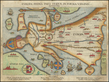
A landmark in the evolution of cartography, this is the final rendition of Europe as featured in Sebastian Munster's seminal work, Cosmographia, issued from a 16th-century German edition and a testament to Munster's indelible influence on the geographical knowledge of the era.
In 1588, Munster's original map of Europe, first published in 1540, was perceived as outdated and no longer reflective of contemporary geographical understanding. Consequently, a new map was designed for inclusion in Munster's Cosmographia, significantly influenced by the map of Europe published by Abraham Ortelius. This final map thus stands as a symbol of cartographic evolution, embodying both Munster's original vision and the progress in geographical understanding over the course of the 16th century.
An eminent scholar of Hebrew and mathematics, Sebastian Munster's contribution to cartographic publication during the mid-16th century is unparalleled. With the first mapping of Germany in 1529, he invited scholars to contribute geographical data about Germany. The enthusiastic response exceeded expectations, with the receipt of vast foreign material, providing him with contemporary—albeit not always accurate—maps for his Geographia published in 1540.
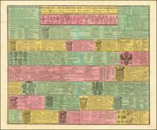
The Cosmographia and the Geographia were monumental in their respective impacts. The Geographia presented not only Ptolemaic maps but also pioneering modern maps, featuring the first distinct maps of the four continents, the first map of England, and the earliest available map of Scandinavia. The Cosmographia, first published in 1544, represented the first German description of the world and played a crucial role in the revival of geographic thought in 16th-century Europe. Approximately 40 editions of the Cosmographia were published between 1544 and 1628.
Münster's Cosmographia was the first German-language description of the world, and one of the defining books of the Renaissance. It contained 471 woodcuts and 26 maps over six volumes. First published in 1544, the Cosmographia was hugely popular in addition to being influential for contemporary cartographers like Mercator and Ortelius. It was published in at least 35 editions by 1628; these editions included examples in Latin, French, Italian, English, and Czech. After Münster's death, Henri Petri, and later his son, Sebastien Petri, took charge of printing editions.
Münster drew from his own travels in the work in addition to using other ancient and more modern sources. These sources included Herodotus, Strabo, and Titius Livius, as well as Marcantonio Sabellico, Beatus Rhenanus, and Aegidius Tschudi. Münster additionally collected reports from recent travelers, which he integrated into his descriptions. These descriptions generally included detailed overviews of the customs, dress, and organization of peoples around the world, earning him a prominent place in the histories of geography and anthropology.
Sebastian Münster (1488-1552) was a cosmographer and professor of Hebrew who taught at Tübingen, Heidelberg, and Basel. He settled in the latter in 1529 and died there, of plague, in 1552. Münster made himself the center of a large network of scholars from whom he obtained geographic descriptions, maps, and directions.
As a young man, Münster joined the Franciscan order, in which he became a priest. He then studied geography at Tübingen, graduating in 1518. He moved to Basel, where he published a Hebrew grammar, one of the first books in Hebrew published in Germany. In 1521 Münster moved again, to Heidelberg, where he continued to publish Hebrew texts and the first German-produced books in Aramaic. After converting to Protestantism in 1529, he took over the chair of Hebrew at Basel, where he published his main Hebrew work, a two-volume Old Testament with a Latin translation.
Münster published his first known map, a map of Germany, in 1525. Three years later, he released a treatise on sundials. In 1540, he published Geographia universalis vetus et nova, an updated edition of Ptolemy’s Geographia. In addition to the Ptolemaic maps, Münster added 21 modern maps. One of Münster’s innovations was to include one map for each continent, a concept that would influence Ortelius and other early atlas makers. The Geographia was reprinted in 1542, 1545, and 1552.
He is best known for his Cosmographia universalis, first published in 1544 and released in at least 35 editions by 1628. It was the first German-language description of the world and contained 471 woodcuts and 26 maps over six volumes. Many of the maps were taken from the Geographia and modified over time. The Cosmographia was widely used in the sixteenth and seventeenth centuries. The text, woodcuts, and maps all influenced geographical thought for generations.
![Carte generale de l'Empire romain [des Sarrasins]](https://storage.googleapis.com/raremaps/img/small/82000.jpg)

![[The First Maps Printed Color] Cartes en Couleur des Lieux Sujets aux tremblements de Terre Dans toutes les parties du Monde Selon le Sisteme de l’impulsion Solaire](https://storage.googleapis.com/raremaps/img/small/52293op.jpg)