|
||

|

|
|

|
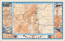
The 1949 revised edition of the Map of Rocky Mountain National Park serves as a fascinating intersection of cartography and environmental history, chronicling the layout and key features of one of America's most beloved national parks. With its meticulous detailing of park amenities and natural features, this map encapsulates the park's standing in the mid-20th century.
The map was printed by the U.S. Government Printing Office, part of the country's commitment to creating and maintaining national parks for public enjoyment and the preservation of America's natural heritage. Rocky Mountain National Park, established in 1915, is a notable part of this legacy, characterized by its stunning mountainous terrain, rugged gorges, alpine lakes, and diverse wildlife. This edition of the map, revised a little over three decades after the park's inception, captures the park's evolving landscape and infrastructure.
Offering more than just a geographical layout, this map is accompanied by a detailed legend indicating patrol cabins, fire lookouts, ranger stations, shelter cabins, public campgrounds, museums, amphitheaters, and more. The delineation of primary roads, secondary roads, and trails further enhances the map's utility, painting a comprehensive picture of the park's accessibility and amenities during the period.
On the verso of the map, an essay about the park accompanies photographic illustrations, providing additional context and insight into the park's historical and environmental significance. The narrative details the park's creation, its range of elevation, and its accessibility from major transportation hubs, contributing to a holistic understanding of the park. Therefore, the 1949 revised Map of Rocky Mountain National Park serves as an important historical document, offering a window into the park's mid-20th-century state and its enduring appeal to visitors.