|
||

|

|
|

|
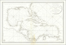
G.W. & C.B. Colton & Co.'s Colton's New Map of the West Indies, Showing Also Part of Central America U.S. Columbia, Venezuela &c. &c. from the Latest Surveys, and Other Reliable Sources of Information, 1869, titled in Spanish Nuevo Mapa Topografico de Las Antillas, y Sus Aguas y Costas Adyacentes, offers a comprehensive geographic overview of the West Indies, including parts of Central America, Columbia, Venezuela, and the Caribbean. It features a detailed rendering of railroads, both completed and proposed, common roads, and depth measurements in fathoms, covering an extensive geographical range from southern Florida to Central America, along with the north coast of South America.
The latter half of the 19th century was a time of considerable expansion and exploration, and maps such as this one played a crucial role in understanding and negotiating newly charted regions. The significant geographical expanse covered in this map reflects the strategic interest of the United States in these regions, particularly in the context of the Monroe Doctrine and the country's growing role as a hemispheric power.
The map includes a small inset of the Bahamas and an inset of the Atlantic.
The detailed transportation routes, including both completed and proposed railroads, provide fascinating insights into the infrastructural development plans of the time. Moreover, the inclusion of common roads and depth measurements in fathoms lends the map a practical utility for a variety of users, ranging from maritime navigators to traders and explorers.
Presented in a large folding format akin to a wall map, this piece embodies the distinctive cartographic craftsmanship of G.W. & C.B. Colton & Co., a firm renowned for its high-quality and detailed maps. As an artifact, this map offers a snapshot of a specific historical period marked by the exploration and gradual integration of the West Indies, Central America, and parts of South America into the sphere of influence of the burgeoning American superpower.
Rarity
Rare. We have not previously offered the map. Not in Rumsey.
G. W. & C. B. Colton was a prominent family firm of mapmakers who were leaders in the American map trade in the nineteenth century. The business was founded by Joseph Hutchins Colton (1800-1893) who bought copyrights to existing maps and oversaw their production. By the 1850s, their output had expanded to include original maps, guidebooks, atlases, and railroad maps. Joseph was succeeded by his sons, George Woolworth (1827-1901) and Charles B. Colton (1831-1916). The firm was renamed G. W. & C. B. Colton as a result. George is thought responsible for their best-known work, the General Atlas, originally published under that title in 1857. In 1898, the brothers merged their business and the firm became Colton, Ohman, & Co., which operated until 1901, when August R. Ohman took on the business alone and dropped the Colton name.
![Indigotoire [Indigo Plantation]](https://storage.googleapis.com/raremaps/img/small/92080.jpg)
![[Martinique, Guadaloupe, Dominica and Marie Galante] . Suite des Isles Antilles 2. Partie](https://storage.googleapis.com/raremaps/img/small/81614.jpg)