|
||

|

|
|

|
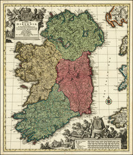
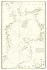
Herman Moll's 1714 map, "A New Map of Ireland Divided into its Provinces, Counties and Baronies," offers an exceptionally detailed visualization of Ireland's provinces, counties, and baronies. The map demonstrates Moll's characteristic precision, distinguishing bishoprics, boroughs, barracks, bogs, passes, bridges, and principal roads, with distances calculated in commonly reputed miles.
The map's creation took place during a time of significant socio-political change in Ireland, with the effects of the 1691 Treaty of Limerick and the subsequent Penal Laws still unfolding. Moll's map, offering detailed information about barracks and troop placements, suggests a landscape contoured as much by political and military exigencies as by physical geography.
The map carries an imprint line indicating its original publishers and sellers, among them Moll himself. The inclusion of Henry Pratt's improvements, notably the detailed road network and computed inter-town distances, further enhances the map's utility and accuracy.
In addition to the main depiction of Ireland, Moll's map includes insets showing plans of Galloway, Waterford, Limerick, Dublin, and Corke. A particular point of interest is the depiction of the Giant's Causeway, complete with an accompanying note describing the natural wonder's unique features. This 1714 edition, thus, stands as an exemplar of Moll's cartographic output, combining geographical precision with a keen eye for detail and context.
Herman Moll (c. 1654-1732) was one of the most important London mapmakers in the first half of the eighteenth century. Moll was probably born in Bremen, Germany, around 1654. He moved to London to escape the Scanian Wars. His earliest work was as an engraver for Moses Pitt on the production of the English Atlas, a failed work which landed Pitt in debtor's prison. Moll also engraved for Sir Jonas Moore, Grenville Collins, John Adair, and the Seller & Price firm. He published his first original maps in the early 1680s and had set up his own shop by the 1690s.
Moll's work quickly helped him become a member of a group which congregated at Jonathan's Coffee House at Number 20 Exchange Alley, Cornhill, where speculators met to trade stock. Moll's circle included the scientist Robert Hooke, the archaeologist William Stuckley, the authors Jonathan Swift and Daniel Defoe, and the intellectually-gifted pirates William Dampier, Woodes Rogers and William Hacke. From these contacts, Moll gained a great deal of privileged information that was included in his maps.
Over the course of his career, he published dozens of geographies, atlases, and histories, not to mention numerous sheet maps. His most famous works are Atlas Geographus, a monthly magazine that ran from 1708 to 1717, and The World Described (1715-54). He also frequently made maps for books, including those of Dampier’s publications and Swift’s Gulliver’s Travels. Moll died in 1732. It is likely that his plates passed to another contemporary, Thomas Bowles, after this death.