|
||

|

|
|

|
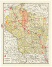
Published in Chicago in 1898, this Rand McNally map of Wisconsin offers a detailed portrayal of the state’s physical and political landscape shortly before the establishment of Rusk County. A particular point of interest lies in the town soon to be named Ladysmith, which at this point was still identified as Warner.
In the late 19th century, Wisconsin was in a state of rapid development and expansion. Industrialization was advancing, railroads were extending their reach, and new counties were being created as the population grew and resources were discovered and exploited. This 1898 map captures this dynamic period, immediately preceding the establishment of Rusk County (initially "Gates" County), which was created from a portion of Chippewa County.
The map provides an extensive view of the existing political and physical geography, outlining the counties, settlements, transportation networks, and topographic features of the time. Warner, which would be renamed Ladysmith and become the county seat of Rusk County around 1901, can be spotted in its original nomenclature, adding to the historical relevance of this map.
Rand McNally, the map's publisher, was a distinguished name in American cartography. The company, founded in the mid-19th century, was renowned for its accuracy and the high quality of its maps. Their maps were considered reliable and up-to-date sources of information, playing a significant role in informing the public about the changing landscapes of the country.
Rand McNally & Co. is a large American map and navigation company best known for its annual atlases. The company got its start in 1856, when William Rand opened a print shop in Chicago. He was joined in 1858 by a new employee, Andrew McNally. Together, the men established their namesake company in 1868. Originally, the company was intended to print the tickets and timetables for the trains running to and through Chicago; their first railway guide was published in 1869.
By 1870, they had shifted from just printing to publishing directories, travel guides, and newspapers. Their first map appeared in 1872 in a railway guide. The map was produced using a new wax engraving method, a cheaper process that gave the company an edge.
By 1880 Rand McNally had entered the education market with globes, wall maps, and geography texts for students. In 1923, Rand McNally published the first Goode’s World Atlas, named after its editor, Dr. J. Paul Goode. For generations afterward, this would be the standard classroom atlas.
In 1899, William Rand left the company, but McNally and his family remained, controlling the company for over a century. In 1904, they published their first road map intended for automobiles and by 1907 were publishing Photo-Auto Guides, which combined photography and mapping to help drivers. In 1924, they produced the Auto Chum, a precursor to their famous road atlases. Rand McNally would remain the leader in road maps and atlases throughout the twentieth century.
In 1937, Rand McNally opened its first store in New York City. Ever on the frontier of technology, Rand McNally pioneered the scribing process for printing tickets in 1958 and printed their first full-color road atlas in 1960. Arthur Robinson developed his now-famous projection of Rand McNally in 1969. By the 1980s, the company was exploring digital reproduction and digital databases of maps for truckers. In the 1990s, they lead the charge to develop trip-planning software and websites. Today, most of its products are available online or in a digital format, including maps for tablets and phones.
![[Ashland Wisconsin]](https://storage.googleapis.com/raremaps/img/small/60288.jpg)