|
||

|

|
|

|
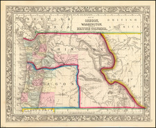
This 1892 map of Idaho, a product of George F. Cram's Chicago publishing house, is an early and intricately detailed representation of Idaho, capturing its railroads, towns, cities, mountain ranges, and more. Published just before the establishment of Canyon County, this map also presents the state's panhandle as an inset, offering a comprehensive view of Idaho's geographic expanse.
The late 19th century was a transformative period in the history of the Western United States. The transcontinental railroads had recently opened up these remote territories to greater settlement and economic activity. Idaho was no exception; the state's development was largely driven by the proliferation of railroads, mining areas, and burgeoning towns and cities, all of which are meticulously depicted in this map.
Additionally, this map provides valuable information about the infrastructure and administrative details of the state. Notably, it includes many early roads, rivers, and delineates both mining areas and Indian reservations, reflecting the state's socio-economic dynamics during this period.
The map employs a clear system of symbols to explain the presence of various landmarks and features. For instance, railroads, the state capitol, unfinished railroads, county seats, and money order post offices are all indicated with specific symbols. An accompanying explanation for these symbols, along with a precise scale of miles, aids comprehension and navigability. The presence of key rail lines, such as the Great Northern, Northern Pacific, and Union Pacific, is also marked, illustrating the state's connectivity to the broader national railroad network.
George F. Cram (1842-1928), or George Franklin Cram, was an American mapmaker and businessman. During the Civil War, Cram served under General William Tecumseh Sherman and participated in his March to the Sea. His letters of that time are now important sources for historians of the Civil War. In 1867, Cram and his uncle, Rufus Blanchard, began the company known by their names in Evanston, Illinois.
Two years later, Cram became sole proprietor and the company was henceforth known as George F. Cram Co. Specializing in atlases, Cram was one of the first American companies to publish a world atlas. One of their most famous products was the Unrivaled Atlas of the World, in print from the 1880s to the 1950s.
Cram died in 1928, seven years after he had merged the business with that of a customer, E.A. Peterson. The new company still bore Cram’s name. Four years later, the Cram Company began to make globes, a branch of the business that would continue until 2012, when the company ceased to operate. For the final several decades of the company’s existence it was controlled by the Douthit family, who sold it just before the company was shuttered.
![[Idaho and western parts of Wyoming & Montana--including Yellowstone and Tetons] Amer. Sep. No. 39. Partie Des Etats-Unis](https://storage.googleapis.com/raremaps/img/small/93545.jpg)