


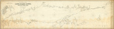
|
||

|

|
|

|
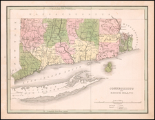
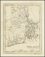
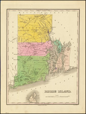
One of the Earliest Obtainable Maps of Rhode Island
Scarce early map of Rhode Island, published in New York and engraved in Philadelphia By William Barker.
The map is quite detailed for its size, showing counties, towns, roads, rivers, lakes, islands, ponds, bays, reefs, along with topographical details. A small plan of Newport appears, as does a part of Block Island.
This map appeared in Volume IV of John Payne's New and Complete Universal Geography… published in New York by John Low at the Shakespeare Head, No. 332 Water-Street, in 1799.
Following the publication of Mathew Carey's American Atlas in 1795, there were a small group of 18th Century works which included a complete set of state maps, including John Reid's American Atlas (1796), Carey's General Atlas (1796), Joseph T. Scott's Gazetteer (1795), Carey's Pocket Atlas (1796) and several works by Jeddidiah Morse. This small group of maps and the few separately issued maps of the region, which are now virtually unobtainable, mark the beginnings of the indigenous cartographic publishing business in America, and are now highly soughtafter.
![(Rhode Island Coastal Defenses) [9 Engineering Plans for Barbette Batteries and Related Fortifications]](https://storage.googleapis.com/raremaps/img/small/92401.jpg)